You are here: Home > Network List > TA - USArray Transportable Network (new EarthScope stations) Stations List
> Station I03D Drain, OR, USA > Earthquake Result Viewer
I03D Drain, OR, USA - Earthquake Result Viewer
| Earthquake location: |
South Of Panama |
| Earthquake latitude/longitude: |
5.5/-82.6 |
| Earthquake time(UTC): |
2012/06/04 (156) 03:15:24 GMT |
| Earthquake Depth: |
7.0 km |
| Earthquake Magnitude: |
5.8 MB, 5.8 MS, 6.3 MW, 6.1 MW |
| Earthquake Catalog/Contributor: |
WHDF/NEIC |
|
| Network: |
TA USArray Transportable Network (new EarthScope stations) |
| Station: |
I03D Drain, OR, USA |
| Lat/Lon: |
43.70 N/123.35 W |
| Elevation: |
140 m |
|
| Distance: |
52.2 deg |
| Az: |
323.182 deg |
| Baz: |
124.667 deg |
| Ray Param: |
0.066891536 |
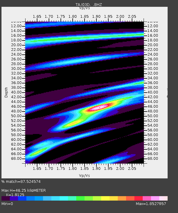
| Estimated Moho Depth: |
46.25 km |
| Estimated Crust Vp/Vs: |
1.91 |
| Assumed Crust Vp: |
6.522 km/s |
| Estimated Crust Vs: |
3.41 km/s |
| Estimated Crust Poisson's Ratio: |
0.31 |
|
| Radial Match: |
87.524574 % |
| Radial Bump: |
386 |
| Transverse Match: |
64.82638 % |
| Transverse Bump: |
400 |
| SOD ConfigId: |
458385 |
| Insert Time: |
2012-10-16 08:57:57.135 +0000 |
| GWidth: |
2.5 |
| Max Bumps: |
400 |
| Tol: |
0.001 |
|

Signal To Noise
| Channel | StoN | STA | LTA |
| TA:I03D: :BHZ:20120604T03:24:05.424988Z | 4.0618033 | 5.2712005E-7 | 1.2977488E-7 |
| TA:I03D: :BHN:20120604T03:24:05.424988Z | 1.068942 | 1.4027755E-7 | 1.312303E-7 |
| TA:I03D: :BHE:20120604T03:24:05.424988Z | 1.1809236 | 1.6619059E-7 | 1.4072933E-7 |
| Arrivals |
| Ps | 6.8 SECOND |
| PpPs | 20 SECOND |
| PsPs/PpSs | 26 SECOND |


