You are here: Home > Network List > TA - USArray Transportable Network (new EarthScope stations) Stations List
> Station H33A Prehn Over North, Clear Lake, SD, USA > Earthquake Result Viewer
H33A Prehn Over North, Clear Lake, SD, USA - Earthquake Result Viewer
| Earthquake location: |
South Of Panama |
| Earthquake latitude/longitude: |
5.5/-82.6 |
| Earthquake time(UTC): |
2012/06/04 (156) 03:15:24 GMT |
| Earthquake Depth: |
7.0 km |
| Earthquake Magnitude: |
5.8 MB, 5.8 MS, 6.3 MW, 6.1 MW |
| Earthquake Catalog/Contributor: |
WHDF/NEIC |
|
| Network: |
TA USArray Transportable Network (new EarthScope stations) |
| Station: |
H33A Prehn Over North, Clear Lake, SD, USA |
| Lat/Lon: |
44.68 N/96.74 W |
| Elevation: |
584 m |
|
| Distance: |
40.9 deg |
| Az: |
344.534 deg |
| Baz: |
158.155 deg |
| Ray Param: |
0.0741058 |
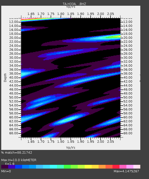
| Estimated Moho Depth: |
10.0 km |
| Estimated Crust Vp/Vs: |
1.60 |
| Assumed Crust Vp: |
6.552 km/s |
| Estimated Crust Vs: |
4.095 km/s |
| Estimated Crust Poisson's Ratio: |
0.18 |
|
| Radial Match: |
88.21742 % |
| Radial Bump: |
400 |
| Transverse Match: |
69.86895 % |
| Transverse Bump: |
400 |
| SOD ConfigId: |
458385 |
| Insert Time: |
2012-10-16 08:58:20.053 +0000 |
| GWidth: |
2.5 |
| Max Bumps: |
400 |
| Tol: |
0.001 |
|

Signal To Noise
| Channel | StoN | STA | LTA |
| TA:H33A: :BHZ:20120604T03:22:37.000Z | 10.4873705 | 1.5561953E-6 | 1.4838757E-7 |
| TA:H33A: :BHN:20120604T03:22:37.000Z | 5.636735 | 2.1075716E-6 | 3.7389935E-7 |
| TA:H33A: :BHE:20120604T03:22:37.000Z | 1.0998526 | 3.5448545E-7 | 3.223027E-7 |
| Arrivals |
| Ps | 1.0 SECOND |
| PpPs | 3.7 SECOND |
| PsPs/PpSs | 4.7 SECOND |


