You are here: Home > Network List > TA - USArray Transportable Network (new EarthScope stations) Stations List
> Station L04D Klamath Falls, OR, USA > Earthquake Result Viewer
L04D Klamath Falls, OR, USA - Earthquake Result Viewer
| Earthquake location: |
South Of Panama |
| Earthquake latitude/longitude: |
5.5/-82.6 |
| Earthquake time(UTC): |
2012/06/04 (156) 03:15:24 GMT |
| Earthquake Depth: |
7.0 km |
| Earthquake Magnitude: |
5.8 MB, 5.8 MS, 6.3 MW, 6.1 MW |
| Earthquake Catalog/Contributor: |
WHDF/NEIC |
|
| Network: |
TA USArray Transportable Network (new EarthScope stations) |
| Station: |
L04D Klamath Falls, OR, USA |
| Lat/Lon: |
42.22 N/122.30 W |
| Elevation: |
1437 m |
|
| Distance: |
50.8 deg |
| Az: |
322.187 deg |
| Baz: |
124.757 deg |
| Ray Param: |
0.06783992 |
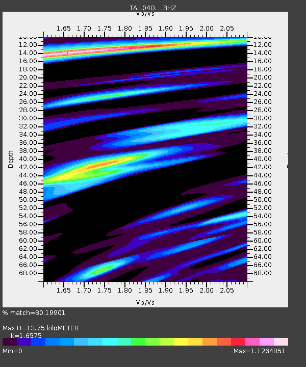
| Estimated Moho Depth: |
13.75 km |
| Estimated Crust Vp/Vs: |
1.66 |
| Assumed Crust Vp: |
6.522 km/s |
| Estimated Crust Vs: |
3.935 km/s |
| Estimated Crust Poisson's Ratio: |
0.21 |
|
| Radial Match: |
80.19901 % |
| Radial Bump: |
400 |
| Transverse Match: |
63.973816 % |
| Transverse Bump: |
400 |
| SOD ConfigId: |
458385 |
| Insert Time: |
2012-10-16 08:58:20.560 +0000 |
| GWidth: |
2.5 |
| Max Bumps: |
400 |
| Tol: |
0.001 |
|
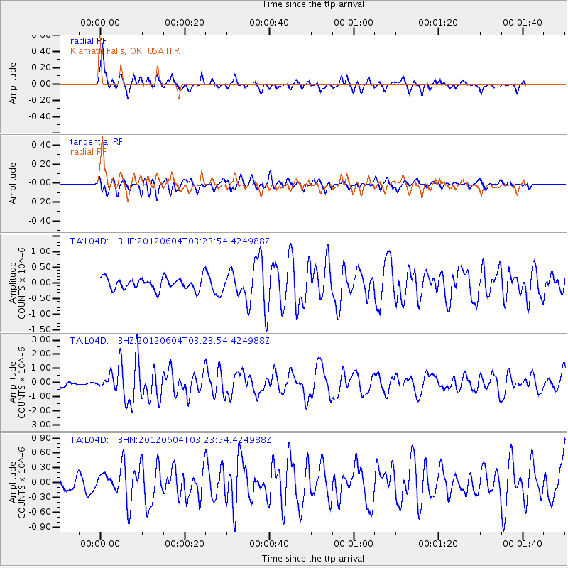
Signal To Noise
| Channel | StoN | STA | LTA |
| TA:L04D: :BHZ:20120604T03:23:54.424988Z | 5.8447676 | 8.030272E-7 | 1.3739249E-7 |
| TA:L04D: :BHN:20120604T03:23:54.424988Z | 1.3031709 | 1.3727808E-7 | 1.0534158E-7 |
| TA:L04D: :BHE:20120604T03:23:54.424988Z | 1.7553169 | 3.3540528E-7 | 1.9107962E-7 |
| Arrivals |
| Ps | 1.5 SECOND |
| PpPs | 5.3 SECOND |
| PsPs/PpSs | 6.7 SECOND |


