You are here: Home > Network List > TA - USArray Transportable Network (new EarthScope stations) Stations List
> Station D34A Park Rapids, MN, USA > Earthquake Result Viewer
D34A Park Rapids, MN, USA - Earthquake Result Viewer

| Earthquake location: |
South Of Panama |
| Earthquake latitude/longitude: |
5.5/-82.6 |
| Earthquake time(UTC): |
2012/06/04 (156) 03:15:24 GMT |
| Earthquake Depth: |
7.0 km |
| Earthquake Magnitude: |
5.8 MB, 5.8 MS, 6.3 MW, 6.1 MW |
| Earthquake Catalog/Contributor: |
WHDF/NEIC |
|
| Network: |
TA USArray Transportable Network (new EarthScope stations) |
| Station: |
D34A Park Rapids, MN, USA |
| Lat/Lon: |
47.09 N/95.20 W |
| Elevation: |
476 m |
|
| Distance: |
42.8 deg |
| Az: |
347.301 deg |
| Baz: |
161.323 deg |
| Ray Param: |
0.0729479 |
| Estimated Moho Depth: |
18.25 km |
| Estimated Crust Vp/Vs: |
1.80 |
| Assumed Crust Vp: |
6.419 km/s |
| Estimated Crust Vs: |
3.566 km/s |
| Estimated Crust Poisson's Ratio: |
0.28 |
|
| Radial Match: |
82.31302 % |
| Radial Bump: |
400 |
| Transverse Match: |
58.2264 % |
| Transverse Bump: |
400 |
| SOD ConfigId: |
458385 |
| Insert Time: |
2012-10-16 09:00:25.381 +0000 |
| GWidth: |
2.5 |
| Max Bumps: |
400 |
| Tol: |
0.001 |
|
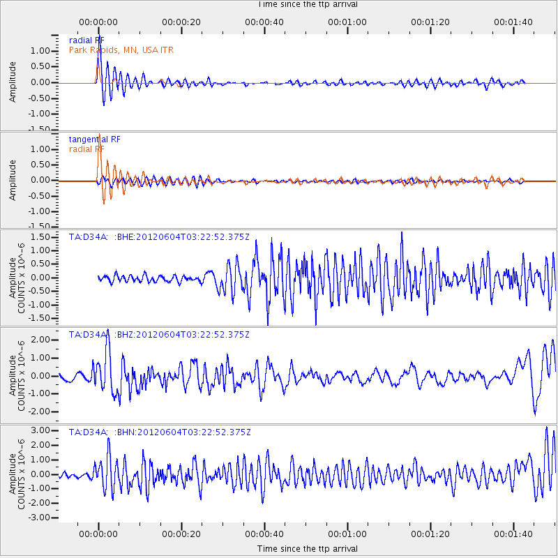
Signal To Noise
| Channel | StoN | STA | LTA |
| TA:D34A: :BHZ:20120604T03:22:52.375Z | 7.6427474 | 1.1836471E-6 | 1.5487194E-7 |
| TA:D34A: :BHN:20120604T03:22:52.375Z | 5.5192165 | 1.1427488E-6 | 2.0704911E-7 |
| TA:D34A: :BHE:20120604T03:22:52.375Z | 4.771756 | 5.1222844E-7 | 1.073459E-7 |
| Arrivals |
| Ps | 2.4 SECOND |
| PpPs | 7.5 SECOND |
| PsPs/PpSs | 9.9 SECOND |


