You are here: Home > Network List > TA - USArray Transportable Network (new EarthScope stations) Stations List
> Station D37A Cotton, MN, USA > Earthquake Result Viewer
D37A Cotton, MN, USA - Earthquake Result Viewer
| Earthquake location: |
South Of Panama |
| Earthquake latitude/longitude: |
5.5/-82.6 |
| Earthquake time(UTC): |
2012/06/04 (156) 03:15:24 GMT |
| Earthquake Depth: |
7.0 km |
| Earthquake Magnitude: |
5.8 MB, 5.8 MS, 6.3 MW, 6.1 MW |
| Earthquake Catalog/Contributor: |
WHDF/NEIC |
|
| Network: |
TA USArray Transportable Network (new EarthScope stations) |
| Station: |
D37A Cotton, MN, USA |
| Lat/Lon: |
47.16 N/92.43 W |
| Elevation: |
413 m |
|
| Distance: |
42.4 deg |
| Az: |
350.008 deg |
| Baz: |
165.339 deg |
| Ray Param: |
0.07322924 |
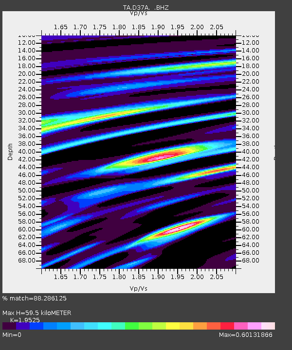
| Estimated Moho Depth: |
59.5 km |
| Estimated Crust Vp/Vs: |
1.95 |
| Assumed Crust Vp: |
6.571 km/s |
| Estimated Crust Vs: |
3.365 km/s |
| Estimated Crust Poisson's Ratio: |
0.32 |
|
| Radial Match: |
88.286125 % |
| Radial Bump: |
307 |
| Transverse Match: |
52.722958 % |
| Transverse Bump: |
400 |
| SOD ConfigId: |
458385 |
| Insert Time: |
2012-10-16 09:00:51.357 +0000 |
| GWidth: |
2.5 |
| Max Bumps: |
400 |
| Tol: |
0.001 |
|
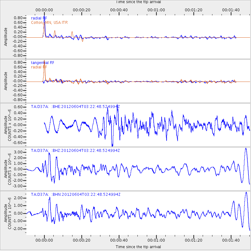
Signal To Noise
| Channel | StoN | STA | LTA |
| TA:D37A: :BHZ:20120604T03:22:48.524994Z | 9.529876 | 1.4557936E-6 | 1.5276102E-7 |
| TA:D37A: :BHN:20120604T03:22:48.524994Z | 6.023604 | 9.0579726E-7 | 1.5037465E-7 |
| TA:D37A: :BHE:20120604T03:22:48.524994Z | 2.3399522 | 3.047128E-7 | 1.302218E-7 |
| Arrivals |
| Ps | 9.2 SECOND |
| PpPs | 25 SECOND |
| PsPs/PpSs | 34 SECOND |


