You are here: Home > Network List > TA - USArray Transportable Network (new EarthScope stations) Stations List
> Station G36A St. Michael, MN, USA > Earthquake Result Viewer
G36A St. Michael, MN, USA - Earthquake Result Viewer
| Earthquake location: |
South Of Panama |
| Earthquake latitude/longitude: |
5.5/-82.6 |
| Earthquake time(UTC): |
2012/06/04 (156) 03:15:24 GMT |
| Earthquake Depth: |
7.0 km |
| Earthquake Magnitude: |
5.8 MB, 5.8 MS, 6.3 MW, 6.1 MW |
| Earthquake Catalog/Contributor: |
WHDF/NEIC |
|
| Network: |
TA USArray Transportable Network (new EarthScope stations) |
| Station: |
G36A St. Michael, MN, USA |
| Lat/Lon: |
45.23 N/93.75 W |
| Elevation: |
293 m |
|
| Distance: |
40.8 deg |
| Az: |
347.878 deg |
| Baz: |
162.792 deg |
| Ray Param: |
0.07422026 |
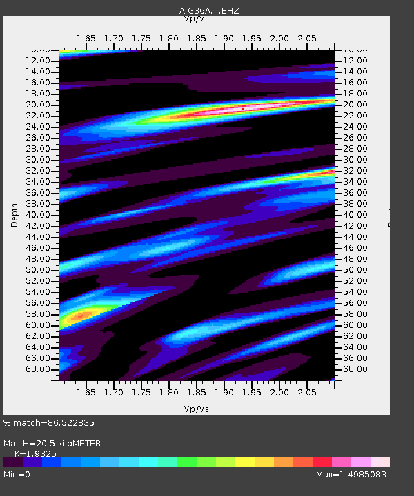
| Estimated Moho Depth: |
20.5 km |
| Estimated Crust Vp/Vs: |
1.93 |
| Assumed Crust Vp: |
6.571 km/s |
| Estimated Crust Vs: |
3.4 km/s |
| Estimated Crust Poisson's Ratio: |
0.32 |
|
| Radial Match: |
86.522835 % |
| Radial Bump: |
400 |
| Transverse Match: |
64.31022 % |
| Transverse Bump: |
400 |
| SOD ConfigId: |
458385 |
| Insert Time: |
2012-10-16 09:01:30.691 +0000 |
| GWidth: |
2.5 |
| Max Bumps: |
400 |
| Tol: |
0.001 |
|
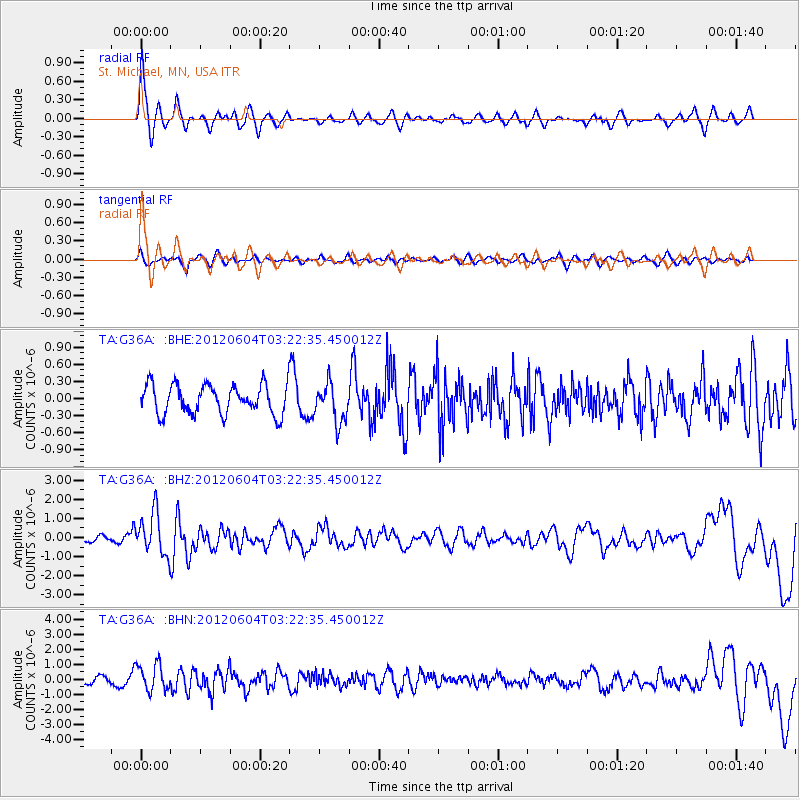
Signal To Noise
| Channel | StoN | STA | LTA |
| TA:G36A: :BHZ:20120604T03:22:35.450012Z | 5.353131 | 1.0977063E-6 | 2.0505875E-7 |
| TA:G36A: :BHN:20120604T03:22:35.450012Z | 3.900984 | 8.917367E-7 | 2.2859277E-7 |
| TA:G36A: :BHE:20120604T03:22:35.450012Z | 1.3283994 | 3.3913778E-7 | 2.5529806E-7 |
| Arrivals |
| Ps | 3.1 SECOND |
| PpPs | 8.6 SECOND |
| PsPs/PpSs | 12 SECOND |


