You are here: Home > Network List > TA - USArray Transportable Network (new EarthScope stations) Stations List
> Station C35A Jirik Farms, Max, MN, USA > Earthquake Result Viewer
C35A Jirik Farms, Max, MN, USA - Earthquake Result Viewer
| Earthquake location: |
South Of Panama |
| Earthquake latitude/longitude: |
5.5/-82.6 |
| Earthquake time(UTC): |
2012/06/04 (156) 03:15:24 GMT |
| Earthquake Depth: |
7.0 km |
| Earthquake Magnitude: |
5.8 MB, 5.8 MS, 6.3 MW, 6.1 MW |
| Earthquake Catalog/Contributor: |
WHDF/NEIC |
|
| Network: |
TA USArray Transportable Network (new EarthScope stations) |
| Station: |
C35A Jirik Farms, Max, MN, USA |
| Lat/Lon: |
47.70 N/93.98 W |
| Elevation: |
426 m |
|
| Distance: |
43.2 deg |
| Az: |
348.732 deg |
| Baz: |
163.264 deg |
| Ray Param: |
0.07273717 |
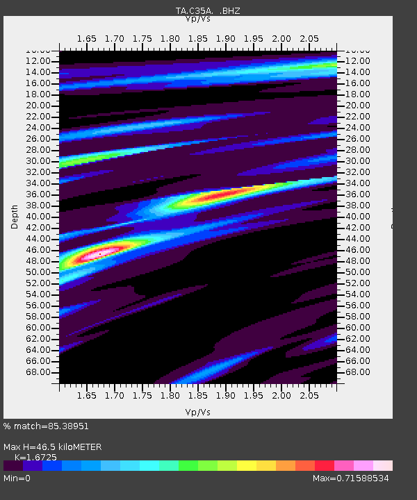
| Estimated Moho Depth: |
46.5 km |
| Estimated Crust Vp/Vs: |
1.67 |
| Assumed Crust Vp: |
6.571 km/s |
| Estimated Crust Vs: |
3.929 km/s |
| Estimated Crust Poisson's Ratio: |
0.22 |
|
| Radial Match: |
85.38951 % |
| Radial Bump: |
200 |
| Transverse Match: |
45.822777 % |
| Transverse Bump: |
354 |
| SOD ConfigId: |
458385 |
| Insert Time: |
2012-10-16 09:01:38.817 +0000 |
| GWidth: |
2.5 |
| Max Bumps: |
400 |
| Tol: |
0.001 |
|

Signal To Noise
| Channel | StoN | STA | LTA |
| TA:C35A: :BHZ:20120604T03:22:55.075012Z | 6.605126 | 9.789928E-7 | 1.4821714E-7 |
| TA:C35A: :BHN:20120604T03:22:55.075012Z | 5.3166275 | 6.2697177E-7 | 1.1792659E-7 |
| TA:C35A: :BHE:20120604T03:22:55.075012Z | 0.999347 | 1.7072284E-7 | 1.708344E-7 |
| Arrivals |
| Ps | 5.1 SECOND |
| PpPs | 18 SECOND |
| PsPs/PpSs | 23 SECOND |


