You are here: Home > Network List > TA - USArray Transportable Network (new EarthScope stations) Stations List
> Station C36A Pine Crest Fram, Angora, MN, USA > Earthquake Result Viewer
C36A Pine Crest Fram, Angora, MN, USA - Earthquake Result Viewer
| Earthquake location: |
South Of Panama |
| Earthquake latitude/longitude: |
5.5/-82.6 |
| Earthquake time(UTC): |
2012/06/04 (156) 03:15:24 GMT |
| Earthquake Depth: |
7.0 km |
| Earthquake Magnitude: |
5.8 MB, 5.8 MS, 6.3 MW, 6.1 MW |
| Earthquake Catalog/Contributor: |
WHDF/NEIC |
|
| Network: |
TA USArray Transportable Network (new EarthScope stations) |
| Station: |
C36A Pine Crest Fram, Angora, MN, USA |
| Lat/Lon: |
47.76 N/92.84 W |
| Elevation: |
410 m |
|
| Distance: |
43.0 deg |
| Az: |
349.837 deg |
| Baz: |
164.912 deg |
| Ray Param: |
0.072835565 |
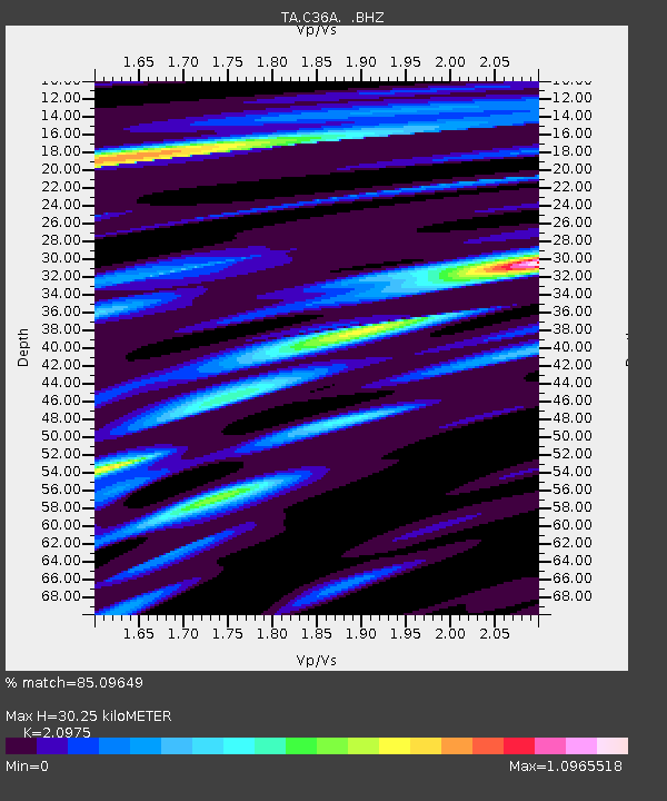
| Estimated Moho Depth: |
30.25 km |
| Estimated Crust Vp/Vs: |
2.10 |
| Assumed Crust Vp: |
6.571 km/s |
| Estimated Crust Vs: |
3.133 km/s |
| Estimated Crust Poisson's Ratio: |
0.35 |
|
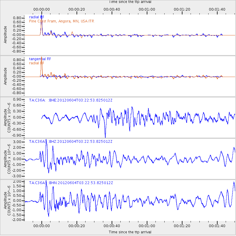
| Radial Match: |
85.09649 % |
| Radial Bump: |
230 |
| Transverse Match: |
60.801193 % |
| Transverse Bump: |
400 |
| SOD ConfigId: |
458385 |
| Insert Time: |
2012-10-16 09:01:43.490 +0000 |
| GWidth: |
2.5 |
| Max Bumps: |
400 |
| Tol: |
0.001 |
|
Signal To Noise
| Channel | StoN | STA | LTA |
| TA:C36A: :BHZ:20120604T03:22:53.825012Z | 12.738544 | 1.5561316E-6 | 1.2215928E-7 |
| TA:C36A: :BHN:20120604T03:22:53.825012Z | 6.897002 | 9.603643E-7 | 1.3924374E-7 |
| TA:C36A: :BHE:20120604T03:22:53.825012Z | 2.0067837 | 2.4477978E-7 | 1.2197617E-7 |
| Arrivals |
| Ps | 5.4 SECOND |
| PpPs | 13 SECOND |
| PsPs/PpSs | 19 SECOND |


