You are here: Home > Network List > TA - USArray Transportable Network (new EarthScope stations) Stations List
> Station B33A Robert and Kassanda Mosher, Grygla, MN, USA > Earthquake Result Viewer
B33A Robert and Kassanda Mosher, Grygla, MN, USA - Earthquake Result Viewer
| Earthquake location: |
South Of Panama |
| Earthquake latitude/longitude: |
5.5/-82.6 |
| Earthquake time(UTC): |
2012/06/04 (156) 03:15:24 GMT |
| Earthquake Depth: |
7.0 km |
| Earthquake Magnitude: |
5.8 MB, 5.8 MS, 6.3 MW, 6.1 MW |
| Earthquake Catalog/Contributor: |
WHDF/NEIC |
|
| Network: |
TA USArray Transportable Network (new EarthScope stations) |
| Station: |
B33A Robert and Kassanda Mosher, Grygla, MN, USA |
| Lat/Lon: |
48.27 N/95.59 W |
| Elevation: |
362 m |
|
| Distance: |
44.0 deg |
| Az: |
347.49 deg |
| Baz: |
161.171 deg |
| Ray Param: |
0.07217015 |
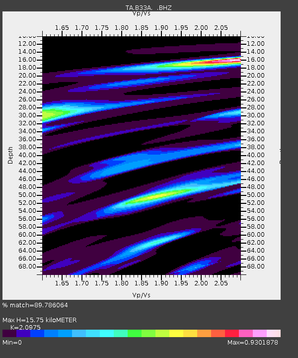
| Estimated Moho Depth: |
15.75 km |
| Estimated Crust Vp/Vs: |
2.10 |
| Assumed Crust Vp: |
6.419 km/s |
| Estimated Crust Vs: |
3.06 km/s |
| Estimated Crust Poisson's Ratio: |
0.35 |
|
| Radial Match: |
89.786064 % |
| Radial Bump: |
293 |
| Transverse Match: |
67.42554 % |
| Transverse Bump: |
336 |
| SOD ConfigId: |
458385 |
| Insert Time: |
2012-10-16 09:03:27.048 +0000 |
| GWidth: |
2.5 |
| Max Bumps: |
400 |
| Tol: |
0.001 |
|

Signal To Noise
| Channel | StoN | STA | LTA |
| TA:B33A: :BHZ:20120604T03:23:02.100006Z | 4.766501 | 1.2034623E-6 | 2.524834E-7 |
| TA:B33A: :BHN:20120604T03:23:02.100006Z | 3.329184 | 7.6752866E-7 | 2.3054558E-7 |
| TA:B33A: :BHE:20120604T03:23:02.100006Z | 1.4488319 | 2.9066913E-7 | 2.0062309E-7 |
| Arrivals |
| Ps | 2.8 SECOND |
| PpPs | 7.2 SECOND |
| PsPs/PpSs | 10 SECOND |


