You are here: Home > Network List > TA - USArray Transportable Network (new EarthScope stations) Stations List
> Station O38A Galt, MO, USA > Earthquake Result Viewer
O38A Galt, MO, USA - Earthquake Result Viewer
| Earthquake location: |
South Of Panama |
| Earthquake latitude/longitude: |
5.5/-82.6 |
| Earthquake time(UTC): |
2012/06/04 (156) 03:15:24 GMT |
| Earthquake Depth: |
7.0 km |
| Earthquake Magnitude: |
5.8 MB, 5.8 MS, 6.3 MW, 6.1 MW |
| Earthquake Catalog/Contributor: |
WHDF/NEIC |
|
| Network: |
TA USArray Transportable Network (new EarthScope stations) |
| Station: |
O38A Galt, MO, USA |
| Lat/Lon: |
40.12 N/93.47 W |
| Elevation: |
266 m |
|
| Distance: |
35.8 deg |
| Az: |
345.646 deg |
| Baz: |
161.227 deg |
| Ray Param: |
0.077017136 |
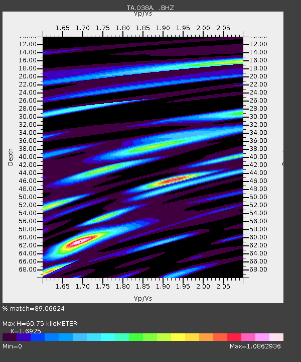
| Estimated Moho Depth: |
60.75 km |
| Estimated Crust Vp/Vs: |
1.69 |
| Assumed Crust Vp: |
6.498 km/s |
| Estimated Crust Vs: |
3.839 km/s |
| Estimated Crust Poisson's Ratio: |
0.23 |
|
| Radial Match: |
89.06624 % |
| Radial Bump: |
400 |
| Transverse Match: |
48.891624 % |
| Transverse Bump: |
400 |
| SOD ConfigId: |
458385 |
| Insert Time: |
2012-10-16 09:04:53.428 +0000 |
| GWidth: |
2.5 |
| Max Bumps: |
400 |
| Tol: |
0.001 |
|

Signal To Noise
| Channel | StoN | STA | LTA |
| TA:O38A: :BHZ:20120604T03:21:54.075012Z | 10.168782 | 1.5114728E-6 | 1.4863852E-7 |
| TA:O38A: :BHN:20120604T03:21:54.075012Z | 4.4688034 | 1.1412241E-6 | 2.5537577E-7 |
| TA:O38A: :BHE:20120604T03:21:54.075012Z | 3.6327555 | 5.6378997E-7 | 1.5519622E-7 |
| Arrivals |
| Ps | 7.0 SECOND |
| PpPs | 23 SECOND |
| PsPs/PpSs | 30 SECOND |


