You are here: Home > Network List > TA - USArray Transportable Network (new EarthScope stations) Stations List
> Station S40A Lebanon, MO, USA > Earthquake Result Viewer
S40A Lebanon, MO, USA - Earthquake Result Viewer
| Earthquake location: |
South Of Panama |
| Earthquake latitude/longitude: |
5.5/-82.6 |
| Earthquake time(UTC): |
2012/06/04 (156) 03:15:24 GMT |
| Earthquake Depth: |
7.0 km |
| Earthquake Magnitude: |
5.8 MB, 5.8 MS, 6.3 MW, 6.1 MW |
| Earthquake Catalog/Contributor: |
WHDF/NEIC |
|
| Network: |
TA USArray Transportable Network (new EarthScope stations) |
| Station: |
S40A Lebanon, MO, USA |
| Lat/Lon: |
37.60 N/92.50 W |
| Elevation: |
336 m |
|
| Distance: |
33.2 deg |
| Az: |
345.503 deg |
| Baz: |
161.716 deg |
| Ray Param: |
0.07832152 |
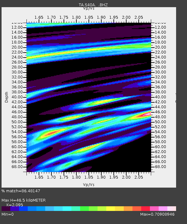
| Estimated Moho Depth: |
46.5 km |
| Estimated Crust Vp/Vs: |
2.10 |
| Assumed Crust Vp: |
6.53 km/s |
| Estimated Crust Vs: |
3.117 km/s |
| Estimated Crust Poisson's Ratio: |
0.35 |
|
| Radial Match: |
86.48147 % |
| Radial Bump: |
291 |
| Transverse Match: |
63.97776 % |
| Transverse Bump: |
400 |
| SOD ConfigId: |
458385 |
| Insert Time: |
2012-10-16 09:06:03.075 +0000 |
| GWidth: |
2.5 |
| Max Bumps: |
400 |
| Tol: |
0.001 |
|

Signal To Noise
| Channel | StoN | STA | LTA |
| TA:S40A: :BHZ:20120604T03:21:31.375Z | 11.818354 | 1.3494791E-6 | 1.1418504E-7 |
| TA:S40A: :BHN:20120604T03:21:31.375Z | 9.979878 | 8.76239E-7 | 8.780057E-8 |
| TA:S40A: :BHE:20120604T03:21:31.375Z | 3.2784941 | 3.7597908E-7 | 1.1468042E-7 |
| Arrivals |
| Ps | 8.3 SECOND |
| PpPs | 21 SECOND |
| PsPs/PpSs | 29 SECOND |


