You are here: Home > Network List > TA - USArray Transportable Network (new EarthScope stations) Stations List
> Station P39B Salisbury, MO, USA > Earthquake Result Viewer
P39B Salisbury, MO, USA - Earthquake Result Viewer
| Earthquake location: |
South Of Panama |
| Earthquake latitude/longitude: |
5.5/-82.6 |
| Earthquake time(UTC): |
2012/06/04 (156) 03:15:24 GMT |
| Earthquake Depth: |
7.0 km |
| Earthquake Magnitude: |
5.8 MB, 5.8 MS, 6.3 MW, 6.1 MW |
| Earthquake Catalog/Contributor: |
WHDF/NEIC |
|
| Network: |
TA USArray Transportable Network (new EarthScope stations) |
| Station: |
P39B Salisbury, MO, USA |
| Lat/Lon: |
39.49 N/92.75 W |
| Elevation: |
226 m |
|
| Distance: |
35.1 deg |
| Az: |
346.21 deg |
| Baz: |
162.145 deg |
| Ray Param: |
0.0774278 |
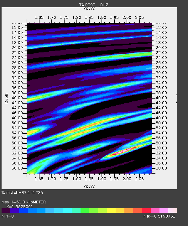
| Estimated Moho Depth: |
61.0 km |
| Estimated Crust Vp/Vs: |
1.98 |
| Assumed Crust Vp: |
6.498 km/s |
| Estimated Crust Vs: |
3.277 km/s |
| Estimated Crust Poisson's Ratio: |
0.33 |
|
| Radial Match: |
87.141235 % |
| Radial Bump: |
327 |
| Transverse Match: |
70.79165 % |
| Transverse Bump: |
400 |
| SOD ConfigId: |
458385 |
| Insert Time: |
2012-10-16 09:07:15.108 +0000 |
| GWidth: |
2.5 |
| Max Bumps: |
400 |
| Tol: |
0.001 |
|
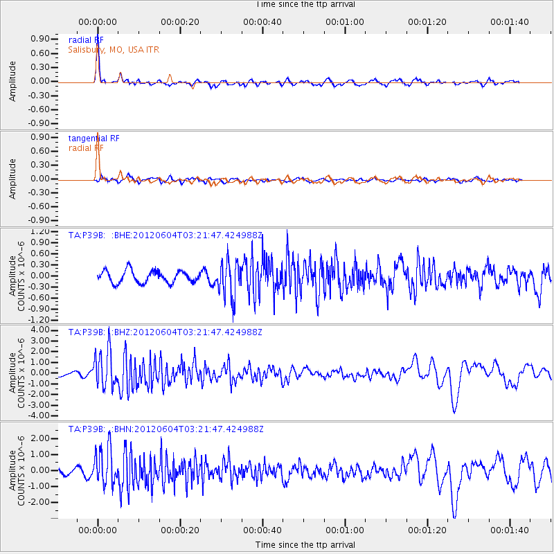
Signal To Noise
| Channel | StoN | STA | LTA |
| TA:P39B: :BHZ:20120604T03:21:47.424988Z | 11.35154 | 1.747196E-6 | 1.539171E-7 |
| TA:P39B: :BHN:20120604T03:21:47.424988Z | 5.2822003 | 1.1657114E-6 | 2.206867E-7 |
| TA:P39B: :BHE:20120604T03:21:47.424988Z | 2.9729886 | 4.8948505E-7 | 1.6464409E-7 |
| Arrivals |
| Ps | 9.9 SECOND |
| PpPs | 26 SECOND |
| PsPs/PpSs | 36 SECOND |


