You are here: Home > Network List > TA - USArray Transportable Network (new EarthScope stations) Stations List
> Station X43A Marvell, AR, USA > Earthquake Result Viewer
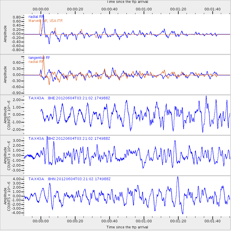
X43A Marvell, AR, USA - Earthquake Result Viewer
*The percent match for this event was below the threshold and hence no stack was calculated.
| Earthquake location: |
South Of Panama |
| Earthquake latitude/longitude: |
5.5/-82.6 |
| Earthquake time(UTC): |
2012/06/04 (156) 03:15:24 GMT |
| Earthquake Depth: |
7.0 km |
| Earthquake Magnitude: |
5.8 MB, 5.8 MS, 6.3 MW, 6.1 MW |
| Earthquake Catalog/Contributor: |
WHDF/NEIC |
|
| Network: |
TA USArray Transportable Network (new EarthScope stations) |
| Station: |
X43A Marvell, AR, USA |
| Lat/Lon: |
34.52 N/90.88 W |
| Elevation: |
53 m |
|
| Distance: |
29.9 deg |
| Az: |
346.125 deg |
| Baz: |
163.196 deg |
| Ray Param: |
$rayparam |
*The percent match for this event was below the threshold and hence was not used in the summary stack. |
|
| Radial Match: |
63.56832 % |
| Radial Bump: |
357 |
| Transverse Match: |
68.9781 % |
| Transverse Bump: |
400 |
| SOD ConfigId: |
458385 |
| Insert Time: |
2012-10-16 09:07:59.008 +0000 |
| GWidth: |
2.5 |
| Max Bumps: |
400 |
| Tol: |
0.001 |
|
Signal To Noise
| Channel | StoN | STA | LTA |
| TA:X43A: :BHZ:20120604T03:21:02.174988Z | 7.5055633 | 1.5258776E-6 | 2.0329955E-7 |
| TA:X43A: :BHN:20120604T03:21:02.174988Z | 2.1537795 | 1.160957E-6 | 5.3903244E-7 |
| TA:X43A: :BHE:20120604T03:21:02.174988Z | 0.8107253 | 5.462449E-7 | 6.7377306E-7 |
| Arrivals |
| Ps | |
| PpPs | |
| PsPs/PpSs | |


