You are here: Home > Network List > TA - USArray Transportable Network (new EarthScope stations) Stations List
> Station Q43A New Douglas, IL, USA > Earthquake Result Viewer
Q43A New Douglas, IL, USA - Earthquake Result Viewer
| Earthquake location: |
South Of Panama |
| Earthquake latitude/longitude: |
5.5/-82.6 |
| Earthquake time(UTC): |
2012/06/04 (156) 03:15:24 GMT |
| Earthquake Depth: |
7.0 km |
| Earthquake Magnitude: |
5.8 MB, 5.8 MS, 6.3 MW, 6.1 MW |
| Earthquake Catalog/Contributor: |
WHDF/NEIC |
|
| Network: |
TA USArray Transportable Network (new EarthScope stations) |
| Station: |
Q43A New Douglas, IL, USA |
| Lat/Lon: |
38.94 N/89.70 W |
| Elevation: |
202 m |
|
| Distance: |
33.9 deg |
| Az: |
349.998 deg |
| Baz: |
167.192 deg |
| Ray Param: |
0.07799914 |
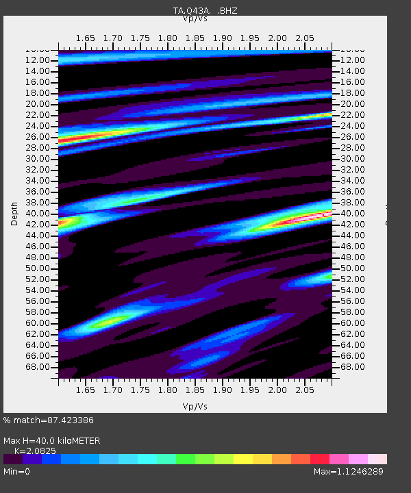
| Estimated Moho Depth: |
40.0 km |
| Estimated Crust Vp/Vs: |
2.08 |
| Assumed Crust Vp: |
6.444 km/s |
| Estimated Crust Vs: |
3.094 km/s |
| Estimated Crust Poisson's Ratio: |
0.35 |
|
| Radial Match: |
87.423386 % |
| Radial Bump: |
317 |
| Transverse Match: |
55.868748 % |
| Transverse Bump: |
400 |
| SOD ConfigId: |
458385 |
| Insert Time: |
2012-10-16 09:08:25.390 +0000 |
| GWidth: |
2.5 |
| Max Bumps: |
400 |
| Tol: |
0.001 |
|

Signal To Noise
| Channel | StoN | STA | LTA |
| TA:Q43A: :BHZ:20120604T03:21:37.450012Z | 6.750416 | 1.5170483E-6 | 2.2473405E-7 |
| TA:Q43A: :BHN:20120604T03:21:37.450012Z | 7.4197063 | 1.0330215E-6 | 1.3922674E-7 |
| TA:Q43A: :BHE:20120604T03:21:37.450012Z | 1.9166777 | 3.9099547E-7 | 2.0399646E-7 |
| Arrivals |
| Ps | 7.2 SECOND |
| PpPs | 18 SECOND |
| PsPs/PpSs | 25 SECOND |


