You are here: Home > Network List > TA - USArray Transportable Network (new EarthScope stations) Stations List
> Station P41A Barry, Barry, IL, USA > Earthquake Result Viewer
P41A Barry, Barry, IL, USA - Earthquake Result Viewer
| Earthquake location: |
South Of Panama |
| Earthquake latitude/longitude: |
5.5/-82.6 |
| Earthquake time(UTC): |
2012/06/04 (156) 03:15:24 GMT |
| Earthquake Depth: |
7.0 km |
| Earthquake Magnitude: |
5.8 MB, 5.8 MS, 6.3 MW, 6.1 MW |
| Earthquake Catalog/Contributor: |
WHDF/NEIC |
|
| Network: |
TA USArray Transportable Network (new EarthScope stations) |
| Station: |
P41A Barry, Barry, IL, USA |
| Lat/Lon: |
39.67 N/91.06 W |
| Elevation: |
215 m |
|
| Distance: |
34.9 deg |
| Az: |
348.492 deg |
| Baz: |
165.088 deg |
| Ray Param: |
0.07752571 |
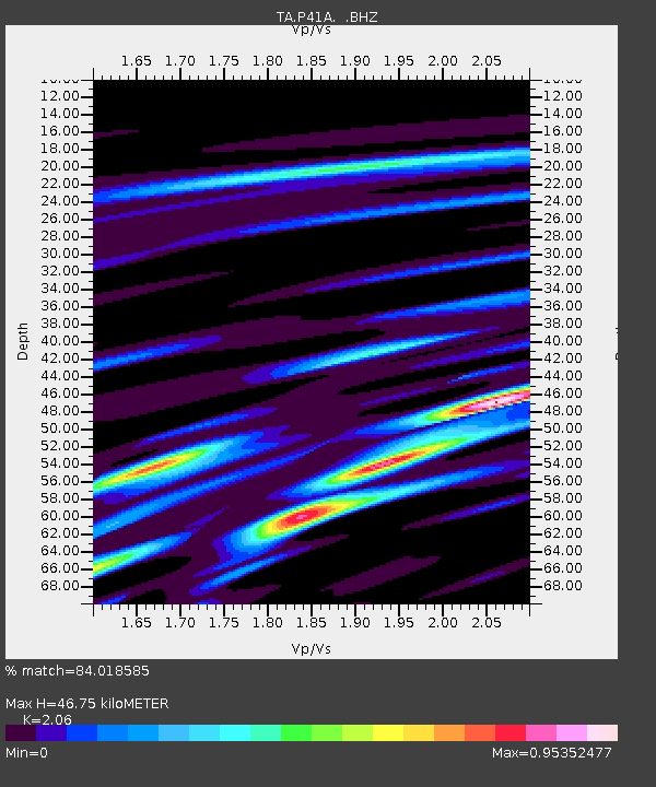
| Estimated Moho Depth: |
46.75 km |
| Estimated Crust Vp/Vs: |
2.06 |
| Assumed Crust Vp: |
6.498 km/s |
| Estimated Crust Vs: |
3.154 km/s |
| Estimated Crust Poisson's Ratio: |
0.35 |
|
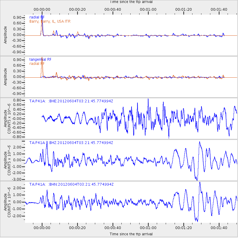
| Radial Match: |
84.018585 % |
| Radial Bump: |
275 |
| Transverse Match: |
32.52525 % |
| Transverse Bump: |
400 |
| SOD ConfigId: |
458385 |
| Insert Time: |
2012-10-16 09:08:35.098 +0000 |
| GWidth: |
2.5 |
| Max Bumps: |
400 |
| Tol: |
0.001 |
|
Signal To Noise
| Channel | StoN | STA | LTA |
| TA:P41A: :BHZ:20120604T03:21:45.774994Z | 4.252922 | 1.1358549E-6 | 2.6707636E-7 |
| TA:P41A: :BHN:20120604T03:21:45.774994Z | 2.5649326 | 6.826845E-7 | 2.6616078E-7 |
| TA:P41A: :BHE:20120604T03:21:45.774994Z | 1.8446797 | 2.2819036E-7 | 1.2370188E-7 |
| Arrivals |
| Ps | 8.2 SECOND |
| PpPs | 21 SECOND |
| PsPs/PpSs | 29 SECOND |


