You are here: Home > Network List > TA - USArray Transportable Network (new EarthScope stations) Stations List
> Station P42A Winchester, IL, USA > Earthquake Result Viewer
P42A Winchester, IL, USA - Earthquake Result Viewer
| Earthquake location: |
South Of Panama |
| Earthquake latitude/longitude: |
5.5/-82.6 |
| Earthquake time(UTC): |
2012/06/04 (156) 03:15:24 GMT |
| Earthquake Depth: |
7.0 km |
| Earthquake Magnitude: |
5.8 MB, 5.8 MS, 6.3 MW, 6.1 MW |
| Earthquake Catalog/Contributor: |
WHDF/NEIC |
|
| Network: |
TA USArray Transportable Network (new EarthScope stations) |
| Station: |
P42A Winchester, IL, USA |
| Lat/Lon: |
39.59 N/90.34 W |
| Elevation: |
197 m |
|
| Distance: |
34.6 deg |
| Az: |
349.395 deg |
| Baz: |
166.286 deg |
| Ray Param: |
0.07764144 |
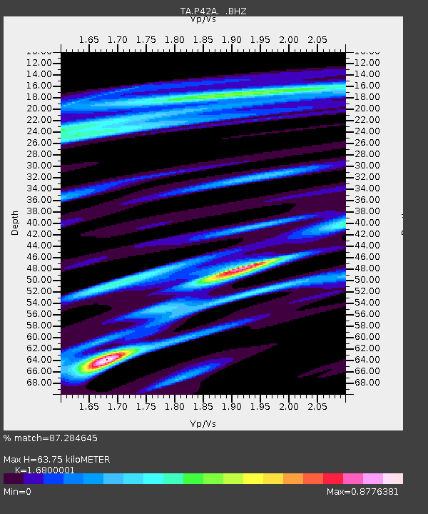
| Estimated Moho Depth: |
63.75 km |
| Estimated Crust Vp/Vs: |
1.68 |
| Assumed Crust Vp: |
6.498 km/s |
| Estimated Crust Vs: |
3.868 km/s |
| Estimated Crust Poisson's Ratio: |
0.23 |
|
| Radial Match: |
87.284645 % |
| Radial Bump: |
286 |
| Transverse Match: |
58.83032 % |
| Transverse Bump: |
400 |
| SOD ConfigId: |
458385 |
| Insert Time: |
2012-10-16 09:09:27.328 +0000 |
| GWidth: |
2.5 |
| Max Bumps: |
400 |
| Tol: |
0.001 |
|

Signal To Noise
| Channel | StoN | STA | LTA |
| TA:P42A: :BHZ:20120604T03:21:43.850006Z | 5.7380466 | 1.3750027E-6 | 2.3962906E-7 |
| TA:P42A: :BHN:20120604T03:21:43.850006Z | 5.196075 | 8.876012E-7 | 1.7082147E-7 |
| TA:P42A: :BHE:20120604T03:21:43.850006Z | 2.4850035 | 4.0023434E-7 | 1.6105986E-7 |
| Arrivals |
| Ps | 7.3 SECOND |
| PpPs | 24 SECOND |
| PsPs/PpSs | 31 SECOND |


