You are here: Home > Network List > TA - USArray Transportable Network (new EarthScope stations) Stations List
> Station W42A Bald Knob, AR, USA > Earthquake Result Viewer
W42A Bald Knob, AR, USA - Earthquake Result Viewer
| Earthquake location: |
South Of Panama |
| Earthquake latitude/longitude: |
5.5/-82.6 |
| Earthquake time(UTC): |
2012/06/04 (156) 03:15:24 GMT |
| Earthquake Depth: |
7.0 km |
| Earthquake Magnitude: |
5.8 MB, 5.8 MS, 6.3 MW, 6.1 MW |
| Earthquake Catalog/Contributor: |
WHDF/NEIC |
|
| Network: |
TA USArray Transportable Network (new EarthScope stations) |
| Station: |
W42A Bald Knob, AR, USA |
| Lat/Lon: |
35.27 N/91.52 W |
| Elevation: |
71 m |
|
| Distance: |
30.8 deg |
| Az: |
345.57 deg |
| Baz: |
162.352 deg |
| Ray Param: |
0.07925299 |
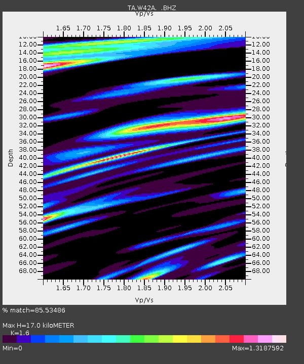
| Estimated Moho Depth: |
17.0 km |
| Estimated Crust Vp/Vs: |
1.60 |
| Assumed Crust Vp: |
6.273 km/s |
| Estimated Crust Vs: |
3.921 km/s |
| Estimated Crust Poisson's Ratio: |
0.18 |
|
| Radial Match: |
85.53486 % |
| Radial Bump: |
400 |
| Transverse Match: |
64.16486 % |
| Transverse Bump: |
400 |
| SOD ConfigId: |
458385 |
| Insert Time: |
2012-10-16 09:10:22.782 +0000 |
| GWidth: |
2.5 |
| Max Bumps: |
400 |
| Tol: |
0.001 |
|
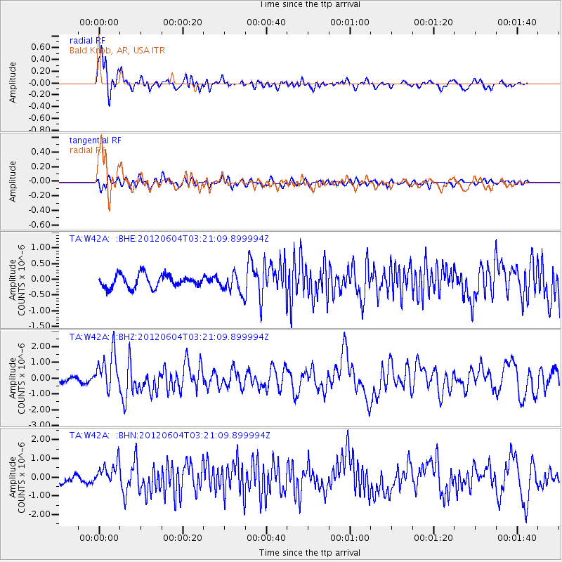
Signal To Noise
| Channel | StoN | STA | LTA |
| TA:W42A: :BHZ:20120604T03:21:09.899994Z | 5.779683 | 1.1925007E-6 | 2.063263E-7 |
| TA:W42A: :BHN:20120604T03:21:09.899994Z | 1.9785761 | 6.033564E-7 | 3.0494476E-7 |
| TA:W42A: :BHE:20120604T03:21:09.899994Z | 1.5654676 | 3.1906637E-7 | 2.0381539E-7 |
| Arrivals |
| Ps | 1.8 SECOND |
| PpPs | 6.5 SECOND |
| PsPs/PpSs | 8.2 SECOND |


