You are here: Home > Network List > TA - USArray Transportable Network (new EarthScope stations) Stations List
> Station M41A Milan, IL, USA > Earthquake Result Viewer
M41A Milan, IL, USA - Earthquake Result Viewer

| Earthquake location: |
South Of Panama |
| Earthquake latitude/longitude: |
5.5/-82.6 |
| Earthquake time(UTC): |
2012/06/04 (156) 03:15:24 GMT |
| Earthquake Depth: |
7.0 km |
| Earthquake Magnitude: |
5.8 MB, 5.8 MS, 6.3 MW, 6.1 MW |
| Earthquake Catalog/Contributor: |
WHDF/NEIC |
|
| Network: |
TA USArray Transportable Network (new EarthScope stations) |
| Station: |
M41A Milan, IL, USA |
| Lat/Lon: |
41.38 N/90.54 W |
| Elevation: |
226 m |
|
| Distance: |
36.4 deg |
| Az: |
349.865 deg |
| Baz: |
166.541 deg |
| Ray Param: |
0.076698445 |
| Estimated Moho Depth: |
50.25 km |
| Estimated Crust Vp/Vs: |
1.64 |
| Assumed Crust Vp: |
6.498 km/s |
| Estimated Crust Vs: |
3.956 km/s |
| Estimated Crust Poisson's Ratio: |
0.21 |
|
| Radial Match: |
89.485664 % |
| Radial Bump: |
247 |
| Transverse Match: |
68.7538 % |
| Transverse Bump: |
400 |
| SOD ConfigId: |
458385 |
| Insert Time: |
2012-10-16 09:10:32.317 +0000 |
| GWidth: |
2.5 |
| Max Bumps: |
400 |
| Tol: |
0.001 |
|
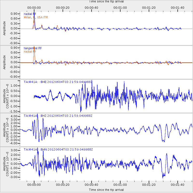
Signal To Noise
| Channel | StoN | STA | LTA |
| TA:M41A: :BHZ:20120604T03:21:59.049988Z | 11.447139 | 2.2333693E-6 | 1.9510283E-7 |
| TA:M41A: :BHN:20120604T03:21:59.049988Z | 7.7574615 | 1.5325343E-6 | 1.9755615E-7 |
| TA:M41A: :BHE:20120604T03:21:59.049988Z | 2.899613 | 6.306705E-7 | 2.1750161E-7 |
| Arrivals |
| Ps | 5.4 SECOND |
| PpPs | 19 SECOND |
| PsPs/PpSs | 24 SECOND |


