You are here: Home > Network List > TA - USArray Transportable Network (new EarthScope stations) Stations List
> Station R43A Red Bud, IL, USA > Earthquake Result Viewer
R43A Red Bud, IL, USA - Earthquake Result Viewer
| Earthquake location: |
South Of Panama |
| Earthquake latitude/longitude: |
5.5/-82.6 |
| Earthquake time(UTC): |
2012/06/04 (156) 03:15:24 GMT |
| Earthquake Depth: |
7.0 km |
| Earthquake Magnitude: |
5.8 MB, 5.8 MS, 6.3 MW, 6.1 MW |
| Earthquake Catalog/Contributor: |
WHDF/NEIC |
|
| Network: |
TA USArray Transportable Network (new EarthScope stations) |
| Station: |
R43A Red Bud, IL, USA |
| Lat/Lon: |
38.28 N/89.93 W |
| Elevation: |
186 m |
|
| Distance: |
33.3 deg |
| Az: |
349.406 deg |
| Baz: |
166.555 deg |
| Ray Param: |
0.07827794 |
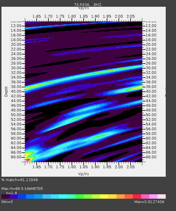
| Estimated Moho Depth: |
69.5 km |
| Estimated Crust Vp/Vs: |
1.60 |
| Assumed Crust Vp: |
6.444 km/s |
| Estimated Crust Vs: |
4.027 km/s |
| Estimated Crust Poisson's Ratio: |
0.18 |
|
| Radial Match: |
91.12849 % |
| Radial Bump: |
292 |
| Transverse Match: |
63.610184 % |
| Transverse Bump: |
376 |
| SOD ConfigId: |
458385 |
| Insert Time: |
2012-10-16 09:10:46.912 +0000 |
| GWidth: |
2.5 |
| Max Bumps: |
400 |
| Tol: |
0.001 |
|

Signal To Noise
| Channel | StoN | STA | LTA |
| TA:R43A: :BHZ:20120604T03:21:32.200012Z | 12.8793955 | 2.0907826E-6 | 1.6233545E-7 |
| TA:R43A: :BHN:20120604T03:21:32.200012Z | 8.842648 | 1.4002823E-6 | 1.5835555E-7 |
| TA:R43A: :BHE:20120604T03:21:32.200012Z | 2.863367 | 5.1314305E-7 | 1.7920966E-7 |
| Arrivals |
| Ps | 7.1 SECOND |
| PpPs | 26 SECOND |
| PsPs/PpSs | 33 SECOND |


