You are here: Home > Network List > TA - USArray Transportable Network (new EarthScope stations) Stations List
> Station F41A Wisconsin Rapids, WI, USA > Earthquake Result Viewer
F41A Wisconsin Rapids, WI, USA - Earthquake Result Viewer
| Earthquake location: |
South Of Panama |
| Earthquake latitude/longitude: |
5.5/-82.6 |
| Earthquake time(UTC): |
2012/06/04 (156) 03:15:24 GMT |
| Earthquake Depth: |
7.0 km |
| Earthquake Magnitude: |
5.8 MB, 5.8 MS, 6.3 MW, 6.1 MW |
| Earthquake Catalog/Contributor: |
WHDF/NEIC |
|
| Network: |
TA USArray Transportable Network (new EarthScope stations) |
| Station: |
F41A Wisconsin Rapids, WI, USA |
| Lat/Lon: |
45.74 N/89.10 W |
| Elevation: |
509 m |
|
| Distance: |
40.5 deg |
| Az: |
352.94 deg |
| Baz: |
169.939 deg |
| Ray Param: |
0.07438706 |
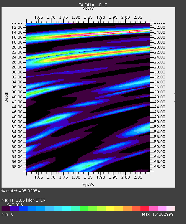
| Estimated Moho Depth: |
13.5 km |
| Estimated Crust Vp/Vs: |
2.02 |
| Assumed Crust Vp: |
6.41 km/s |
| Estimated Crust Vs: |
3.181 km/s |
| Estimated Crust Poisson's Ratio: |
0.34 |
|
| Radial Match: |
85.93054 % |
| Radial Bump: |
312 |
| Transverse Match: |
58.148094 % |
| Transverse Bump: |
400 |
| SOD ConfigId: |
458385 |
| Insert Time: |
2012-10-16 09:12:26.844 +0000 |
| GWidth: |
2.5 |
| Max Bumps: |
400 |
| Tol: |
0.001 |
|

Signal To Noise
| Channel | StoN | STA | LTA |
| TA:F41A: :BHZ:20120604T03:22:33.125Z | 4.2036366 | 1.1198888E-6 | 2.664095E-7 |
| TA:F41A: :BHN:20120604T03:22:33.125Z | 3.7145486 | 7.6953006E-7 | 2.0716651E-7 |
| TA:F41A: :BHE:20120604T03:22:33.125Z | 1.7154832 | 2.3172032E-7 | 1.3507584E-7 |
| Arrivals |
| Ps | 2.3 SECOND |
| PpPs | 6.0 SECOND |
| PsPs/PpSs | 8.2 SECOND |


