You are here: Home > Network List > US - United States National Seismic Network Stations List
> Station MSO Missoula, Montana, USA > Earthquake Result Viewer
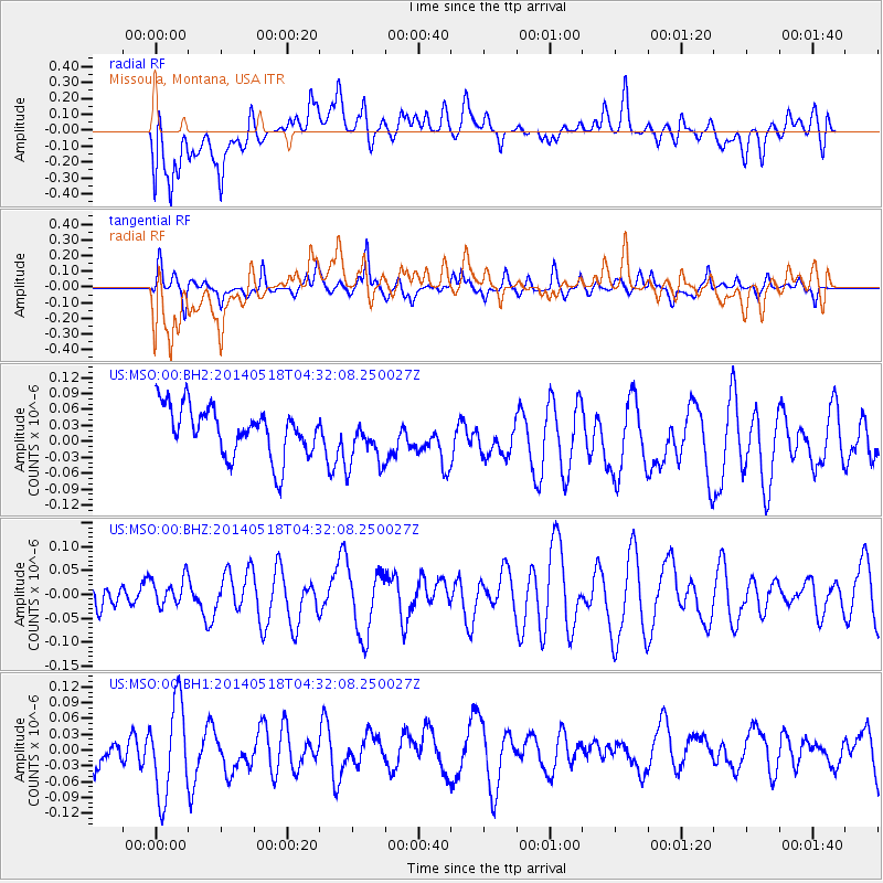
MSO Missoula, Montana, USA - Earthquake Result Viewer
*The percent match for this event was below the threshold and hence no stack was calculated.
| Earthquake location: |
Southeast Of Loyalty Islands |
| Earthquake latitude/longitude: |
-21.4/169.8 |
| Earthquake time(UTC): |
2014/05/18 (138) 04:19:18 GMT |
| Earthquake Depth: |
72 km |
| Earthquake Magnitude: |
5.6 MW |
| Earthquake Catalog/Contributor: |
ISC/ISC |
|
| Network: |
US United States National Seismic Network |
| Station: |
MSO Missoula, Montana, USA |
| Lat/Lon: |
46.83 N/113.94 W |
| Elevation: |
1264 m |
|
| Distance: |
96.4 deg |
| Az: |
42.155 deg |
| Baz: |
245.661 deg |
| Ray Param: |
$rayparam |
*The percent match for this event was below the threshold and hence was not used in the summary stack. |
|
| Radial Match: |
48.101738 % |
| Radial Bump: |
400 |
| Transverse Match: |
44.654224 % |
| Transverse Bump: |
339 |
| SOD ConfigId: |
3390531 |
| Insert Time: |
2019-04-11 22:53:25.691 +0000 |
| GWidth: |
2.5 |
| Max Bumps: |
400 |
| Tol: |
0.001 |
|
Signal To Noise
| Channel | StoN | STA | LTA |
| US:MSO:00:BHZ:20140518T04:32:08.250027Z | 0.95671415 | 3.19096E-8 | 3.3353327E-8 |
| US:MSO:00:BH1:20140518T04:32:08.250027Z | 2.7080364 | 8.7160885E-8 | 3.218601E-8 |
| US:MSO:00:BH2:20140518T04:32:08.250027Z | 1.0814062 | 4.9388568E-8 | 4.567069E-8 |
| Arrivals |
| Ps | |
| PpPs | |
| PsPs/PpSs | |


