You are here: Home > Network List > TA - USArray Transportable Network (new EarthScope stations) Stations List
> Station F43A Flat Rock, Escanaba, MI, USA > Earthquake Result Viewer
F43A Flat Rock, Escanaba, MI, USA - Earthquake Result Viewer
| Earthquake location: |
South Of Panama |
| Earthquake latitude/longitude: |
5.5/-82.6 |
| Earthquake time(UTC): |
2012/06/04 (156) 03:15:24 GMT |
| Earthquake Depth: |
7.0 km |
| Earthquake Magnitude: |
5.8 MB, 5.8 MS, 6.3 MW, 6.1 MW |
| Earthquake Catalog/Contributor: |
WHDF/NEIC |
|
| Network: |
TA USArray Transportable Network (new EarthScope stations) |
| Station: |
F43A Flat Rock, Escanaba, MI, USA |
| Lat/Lon: |
45.83 N/87.17 W |
| Elevation: |
233 m |
|
| Distance: |
40.4 deg |
| Az: |
355.026 deg |
| Baz: |
172.91 deg |
| Ray Param: |
0.074447826 |
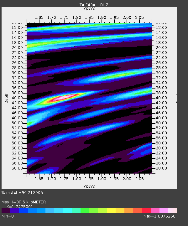
| Estimated Moho Depth: |
39.5 km |
| Estimated Crust Vp/Vs: |
1.75 |
| Assumed Crust Vp: |
6.53 km/s |
| Estimated Crust Vs: |
3.737 km/s |
| Estimated Crust Poisson's Ratio: |
0.26 |
|
| Radial Match: |
90.213005 % |
| Radial Bump: |
286 |
| Transverse Match: |
64.16474 % |
| Transverse Bump: |
400 |
| SOD ConfigId: |
458385 |
| Insert Time: |
2012-10-16 09:13:14.689 +0000 |
| GWidth: |
2.5 |
| Max Bumps: |
400 |
| Tol: |
0.001 |
|
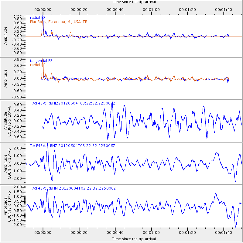
Signal To Noise
| Channel | StoN | STA | LTA |
| TA:F43A: :BHZ:20120604T03:22:32.225006Z | 7.0296187 | 1.2096153E-6 | 1.720741E-7 |
| TA:F43A: :BHN:20120604T03:22:32.225006Z | 3.5979662 | 7.9118996E-7 | 2.198992E-7 |
| TA:F43A: :BHE:20120604T03:22:32.225006Z | 1.7345145 | 2.208453E-7 | 1.2732399E-7 |
| Arrivals |
| Ps | 4.9 SECOND |
| PpPs | 15 SECOND |
| PsPs/PpSs | 20 SECOND |


