You are here: Home > Network List > TA - USArray Transportable Network (new EarthScope stations) Stations List
> Station I42A Draeger Farm, Ripon, WI, USA > Earthquake Result Viewer
I42A Draeger Farm, Ripon, WI, USA - Earthquake Result Viewer
| Earthquake location: |
South Of Panama |
| Earthquake latitude/longitude: |
5.5/-82.6 |
| Earthquake time(UTC): |
2012/06/04 (156) 03:15:24 GMT |
| Earthquake Depth: |
7.0 km |
| Earthquake Magnitude: |
5.8 MB, 5.8 MS, 6.3 MW, 6.1 MW |
| Earthquake Catalog/Contributor: |
WHDF/NEIC |
|
| Network: |
TA USArray Transportable Network (new EarthScope stations) |
| Station: |
I42A Draeger Farm, Ripon, WI, USA |
| Lat/Lon: |
43.89 N/88.91 W |
| Elevation: |
298 m |
|
| Distance: |
38.6 deg |
| Az: |
352.641 deg |
| Baz: |
169.843 deg |
| Ray Param: |
0.07545612 |
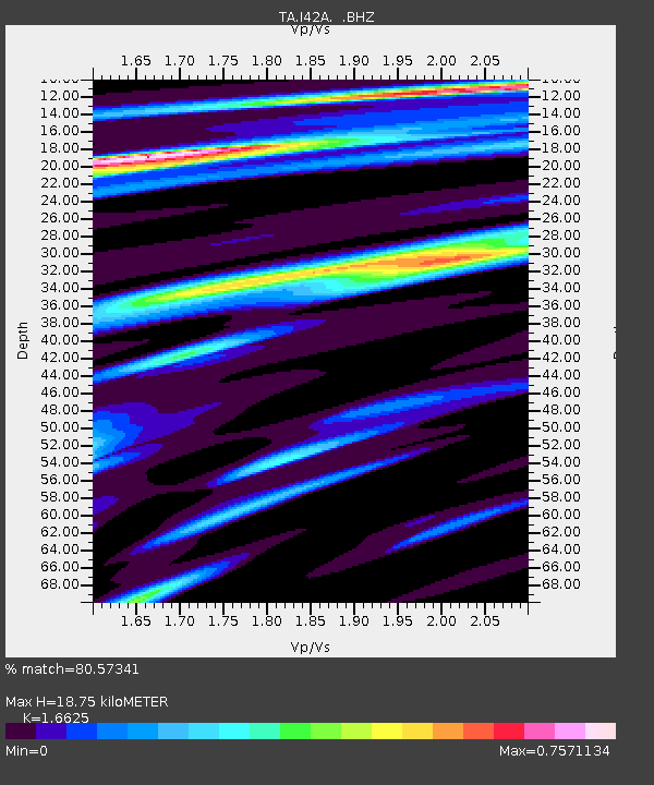
| Estimated Moho Depth: |
18.75 km |
| Estimated Crust Vp/Vs: |
1.66 |
| Assumed Crust Vp: |
6.571 km/s |
| Estimated Crust Vs: |
3.952 km/s |
| Estimated Crust Poisson's Ratio: |
0.22 |
|
| Radial Match: |
80.57341 % |
| Radial Bump: |
262 |
| Transverse Match: |
56.19948 % |
| Transverse Bump: |
390 |
| SOD ConfigId: |
458385 |
| Insert Time: |
2012-10-16 09:13:38.511 +0000 |
| GWidth: |
2.5 |
| Max Bumps: |
400 |
| Tol: |
0.001 |
|
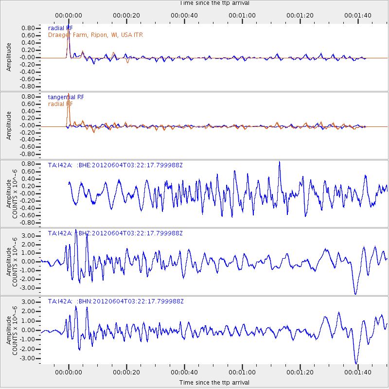
Signal To Noise
| Channel | StoN | STA | LTA |
| TA:I42A: :BHZ:20120604T03:22:17.799988Z | 6.9209185 | 1.815601E-6 | 2.6233528E-7 |
| TA:I42A: :BHN:20120604T03:22:17.799988Z | 10.614152 | 1.2757171E-6 | 1.201902E-7 |
| TA:I42A: :BHE:20120604T03:22:17.799988Z | 1.2539505 | 2.3618742E-7 | 1.8835466E-7 |
| Arrivals |
| Ps | 2.1 SECOND |
| PpPs | 7.0 SECOND |
| PsPs/PpSs | 9.1 SECOND |


