You are here: Home > Network List > TA - USArray Transportable Network (new EarthScope stations) Stations List
> Station G42A Mountain, WI, USA > Earthquake Result Viewer
G42A Mountain, WI, USA - Earthquake Result Viewer
| Earthquake location: |
South Of Panama |
| Earthquake latitude/longitude: |
5.5/-82.6 |
| Earthquake time(UTC): |
2012/06/04 (156) 03:15:24 GMT |
| Earthquake Depth: |
7.0 km |
| Earthquake Magnitude: |
5.8 MB, 5.8 MS, 6.3 MW, 6.1 MW |
| Earthquake Catalog/Contributor: |
WHDF/NEIC |
|
| Network: |
TA USArray Transportable Network (new EarthScope stations) |
| Station: |
G42A Mountain, WI, USA |
| Lat/Lon: |
45.24 N/88.43 W |
| Elevation: |
315 m |
|
| Distance: |
39.9 deg |
| Az: |
353.539 deg |
| Baz: |
170.878 deg |
| Ray Param: |
0.07471519 |
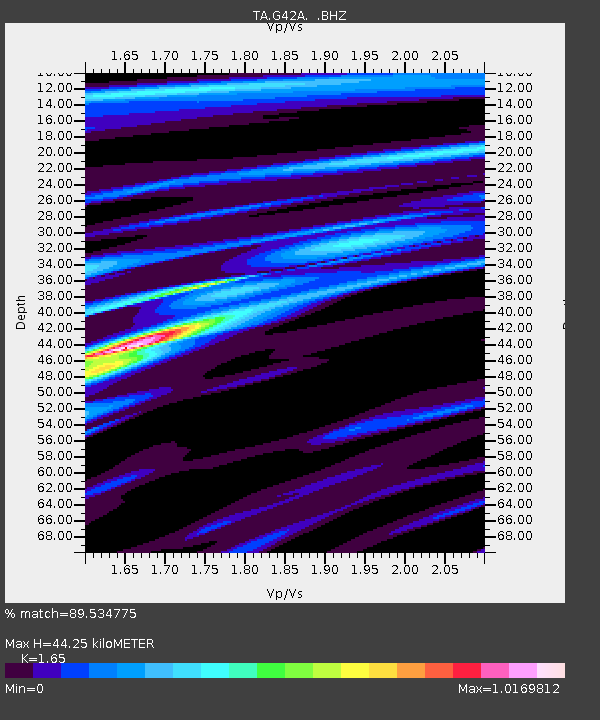
| Estimated Moho Depth: |
44.25 km |
| Estimated Crust Vp/Vs: |
1.65 |
| Assumed Crust Vp: |
6.41 km/s |
| Estimated Crust Vs: |
3.885 km/s |
| Estimated Crust Poisson's Ratio: |
0.21 |
|
| Radial Match: |
89.534775 % |
| Radial Bump: |
251 |
| Transverse Match: |
53.68775 % |
| Transverse Bump: |
400 |
| SOD ConfigId: |
458385 |
| Insert Time: |
2012-10-16 09:13:48.142 +0000 |
| GWidth: |
2.5 |
| Max Bumps: |
400 |
| Tol: |
0.001 |
|

Signal To Noise
| Channel | StoN | STA | LTA |
| TA:G42A: :BHZ:20120604T03:22:28.424988Z | 7.6038785 | 1.3305669E-6 | 1.7498529E-7 |
| TA:G42A: :BHN:20120604T03:22:28.424988Z | 7.773346 | 7.863317E-7 | 1.0115743E-7 |
| TA:G42A: :BHE:20120604T03:22:28.424988Z | 1.401798 | 2.1559265E-7 | 1.5379723E-7 |
| Arrivals |
| Ps | 4.8 SECOND |
| PpPs | 17 SECOND |
| PsPs/PpSs | 22 SECOND |


