You are here: Home > Network List > G - GEOSCOPE Stations List
> Station SCZ Chualar Canyon, Santa Cruz, California, U.S.A. > Earthquake Result Viewer
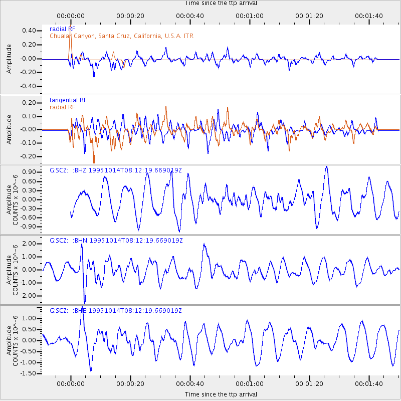
SCZ Chualar Canyon, Santa Cruz, California, U.S.A. - Earthquake Result Viewer
*The percent match for this event was below the threshold and hence no stack was calculated.
| Earthquake location: |
South Of Fiji Islands |
| Earthquake latitude/longitude: |
-25.6/-177.5 |
| Earthquake time(UTC): |
1995/10/14 (287) 08:00:41 GMT |
| Earthquake Depth: |
70 km |
| Earthquake Magnitude: |
5.9 MB, 6.2 UNKNOWN, 6.2 MW |
| Earthquake Catalog/Contributor: |
WHDF/NEIC |
|
| Network: |
G GEOSCOPE |
| Station: |
SCZ Chualar Canyon, Santa Cruz, California, U.S.A. |
| Lat/Lon: |
36.60 N/121.40 W |
| Elevation: |
261 m |
|
| Distance: |
81.3 deg |
| Az: |
42.508 deg |
| Baz: |
229.319 deg |
| Ray Param: |
$rayparam |
*The percent match for this event was below the threshold and hence was not used in the summary stack. |
|
| Radial Match: |
54.942085 % |
| Radial Bump: |
351 |
| Transverse Match: |
50.734505 % |
| Transverse Bump: |
293 |
| SOD ConfigId: |
4480 |
| Insert Time: |
2010-02-26 23:58:17.227 +0000 |
| GWidth: |
2.5 |
| Max Bumps: |
400 |
| Tol: |
0.001 |
|
Signal To Noise
| Channel | StoN | STA | LTA |
| G:SCZ: :BHN:19951014T08:12:19.669019Z | 3.8880377 | 1.0070173E-6 | 2.59004E-7 |
| G:SCZ: :BHE:19951014T08:12:19.669019Z | 2.267595 | 6.867826E-7 | 3.0286827E-7 |
| G:SCZ: :BHZ:19951014T08:12:19.669019Z | 1.2461702 | 5.190097E-7 | 4.1648377E-7 |
| Arrivals |
| Ps | |
| PpPs | |
| PsPs/PpSs | |


