You are here: Home > Network List > TA - USArray Transportable Network (new EarthScope stations) Stations List
> Station C40A Isle Royale National Park, MI, USA > Earthquake Result Viewer
C40A Isle Royale National Park, MI, USA - Earthquake Result Viewer
| Earthquake location: |
South Of Panama |
| Earthquake latitude/longitude: |
5.5/-82.6 |
| Earthquake time(UTC): |
2012/06/04 (156) 03:15:24 GMT |
| Earthquake Depth: |
7.0 km |
| Earthquake Magnitude: |
5.8 MB, 5.8 MS, 6.3 MW, 6.1 MW |
| Earthquake Catalog/Contributor: |
WHDF/NEIC |
|
| Network: |
TA USArray Transportable Network (new EarthScope stations) |
| Station: |
C40A Isle Royale National Park, MI, USA |
| Lat/Lon: |
47.92 N/89.15 W |
| Elevation: |
216 m |
|
| Distance: |
42.6 deg |
| Az: |
353.456 deg |
| Baz: |
170.291 deg |
| Ray Param: |
0.073072754 |
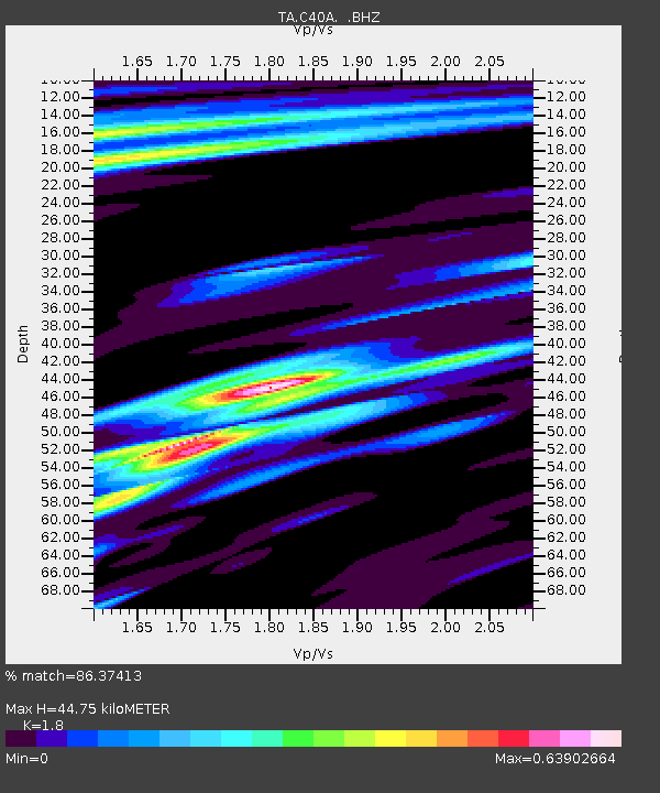
| Estimated Moho Depth: |
44.75 km |
| Estimated Crust Vp/Vs: |
1.80 |
| Assumed Crust Vp: |
6.467 km/s |
| Estimated Crust Vs: |
3.593 km/s |
| Estimated Crust Poisson's Ratio: |
0.28 |
|
| Radial Match: |
86.37413 % |
| Radial Bump: |
343 |
| Transverse Match: |
54.909397 % |
| Transverse Bump: |
375 |
| SOD ConfigId: |
458385 |
| Insert Time: |
2012-10-16 09:13:58.354 +0000 |
| GWidth: |
2.5 |
| Max Bumps: |
400 |
| Tol: |
0.001 |
|

Signal To Noise
| Channel | StoN | STA | LTA |
| TA:C40A: :BHZ:20120604T03:22:50.750Z | 6.8411493 | 1.6683027E-6 | 2.4386293E-7 |
| TA:C40A: :BHN:20120604T03:22:50.750Z | 3.8704755 | 7.9954725E-7 | 2.0657598E-7 |
| TA:C40A: :BHE:20120604T03:22:50.750Z | 1.0910531 | 1.9663227E-7 | 1.8022246E-7 |
| Arrivals |
| Ps | 5.9 SECOND |
| PpPs | 18 SECOND |
| PsPs/PpSs | 24 SECOND |


