You are here: Home > Network List > TA - USArray Transportable Network (new EarthScope stations) Stations List
> Station N45A Kentland, IN, USA > Earthquake Result Viewer
N45A Kentland, IN, USA - Earthquake Result Viewer
| Earthquake location: |
South Of Panama |
| Earthquake latitude/longitude: |
5.5/-82.6 |
| Earthquake time(UTC): |
2012/06/04 (156) 03:15:24 GMT |
| Earthquake Depth: |
7.0 km |
| Earthquake Magnitude: |
5.8 MB, 5.8 MS, 6.3 MW, 6.1 MW |
| Earthquake Catalog/Contributor: |
WHDF/NEIC |
|
| Network: |
TA USArray Transportable Network (new EarthScope stations) |
| Station: |
N45A Kentland, IN, USA |
| Lat/Lon: |
40.85 N/87.51 W |
| Elevation: |
206 m |
|
| Distance: |
35.5 deg |
| Az: |
353.524 deg |
| Baz: |
171.489 deg |
| Ray Param: |
0.077216215 |
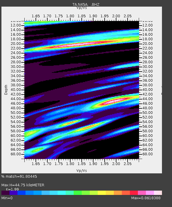
| Estimated Moho Depth: |
44.75 km |
| Estimated Crust Vp/Vs: |
1.99 |
| Assumed Crust Vp: |
6.498 km/s |
| Estimated Crust Vs: |
3.265 km/s |
| Estimated Crust Poisson's Ratio: |
0.33 |
|
| Radial Match: |
91.80445 % |
| Radial Bump: |
312 |
| Transverse Match: |
42.003887 % |
| Transverse Bump: |
293 |
| SOD ConfigId: |
458385 |
| Insert Time: |
2012-10-16 09:14:07.015 +0000 |
| GWidth: |
2.5 |
| Max Bumps: |
400 |
| Tol: |
0.001 |
|
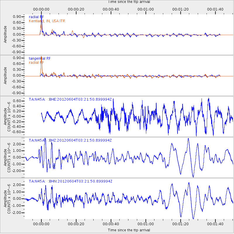
Signal To Noise
| Channel | StoN | STA | LTA |
| TA:N45A: :BHZ:20120604T03:21:50.899994Z | 6.642761 | 1.4191749E-6 | 2.136423E-7 |
| TA:N45A: :BHN:20120604T03:21:50.899994Z | 3.8245947 | 8.736551E-7 | 2.2843076E-7 |
| TA:N45A: :BHE:20120604T03:21:50.899994Z | 1.4915768 | 2.1085675E-7 | 1.41365E-7 |
| Arrivals |
| Ps | 7.3 SECOND |
| PpPs | 19 SECOND |
| PsPs/PpSs | 27 SECOND |


