You are here: Home > Network List > TA - USArray Transportable Network (new EarthScope stations) Stations List
> Station J42A Columbus, WI, USA > Earthquake Result Viewer
J42A Columbus, WI, USA - Earthquake Result Viewer

| Earthquake location: |
South Of Panama |
| Earthquake latitude/longitude: |
5.5/-82.6 |
| Earthquake time(UTC): |
2012/06/04 (156) 03:15:24 GMT |
| Earthquake Depth: |
7.0 km |
| Earthquake Magnitude: |
5.8 MB, 5.8 MS, 6.3 MW, 6.1 MW |
| Earthquake Catalog/Contributor: |
WHDF/NEIC |
|
| Network: |
TA USArray Transportable Network (new EarthScope stations) |
| Station: |
J42A Columbus, WI, USA |
| Lat/Lon: |
43.32 N/89.12 W |
| Elevation: |
313 m |
|
| Distance: |
38.1 deg |
| Az: |
352.233 deg |
| Baz: |
169.378 deg |
| Ray Param: |
0.07576564 |
| Estimated Moho Depth: |
52.5 km |
| Estimated Crust Vp/Vs: |
1.60 |
| Assumed Crust Vp: |
6.571 km/s |
| Estimated Crust Vs: |
4.107 km/s |
| Estimated Crust Poisson's Ratio: |
0.18 |
|
| Radial Match: |
89.052185 % |
| Radial Bump: |
225 |
| Transverse Match: |
46.662167 % |
| Transverse Bump: |
400 |
| SOD ConfigId: |
458385 |
| Insert Time: |
2012-10-16 09:14:26.421 +0000 |
| GWidth: |
2.5 |
| Max Bumps: |
400 |
| Tol: |
0.001 |
|
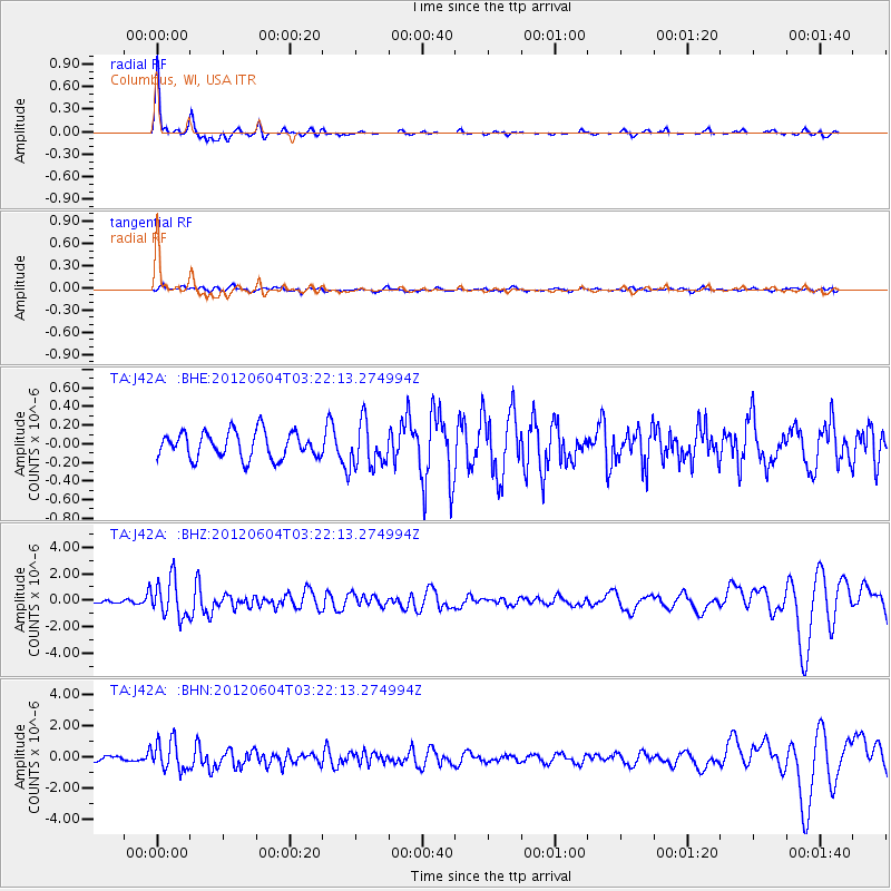
Signal To Noise
| Channel | StoN | STA | LTA |
| TA:J42A: :BHZ:20120604T03:22:13.274994Z | 7.711112 | 1.4472693E-6 | 1.8768618E-7 |
| TA:J42A: :BHN:20120604T03:22:13.274994Z | 6.0997863 | 9.468375E-7 | 1.552247E-7 |
| TA:J42A: :BHE:20120604T03:22:13.274994Z | 1.6444366 | 2.3099436E-7 | 1.404702E-7 |
| Arrivals |
| Ps | 5.2 SECOND |
| PpPs | 19 SECOND |
| PsPs/PpSs | 24 SECOND |


