You are here: Home > Network List > TA - USArray Transportable Network (new EarthScope stations) Stations List
> Station O45A Potomac, IL, USA > Earthquake Result Viewer
O45A Potomac, IL, USA - Earthquake Result Viewer
| Earthquake location: |
South Of Panama |
| Earthquake latitude/longitude: |
5.5/-82.6 |
| Earthquake time(UTC): |
2012/06/04 (156) 03:15:24 GMT |
| Earthquake Depth: |
7.0 km |
| Earthquake Magnitude: |
5.8 MB, 5.8 MS, 6.3 MW, 6.1 MW |
| Earthquake Catalog/Contributor: |
WHDF/NEIC |
|
| Network: |
TA USArray Transportable Network (new EarthScope stations) |
| Station: |
O45A Potomac, IL, USA |
| Lat/Lon: |
40.25 N/87.72 W |
| Elevation: |
208 m |
|
| Distance: |
34.9 deg |
| Az: |
353.088 deg |
| Baz: |
170.995 deg |
| Ray Param: |
0.07751065 |
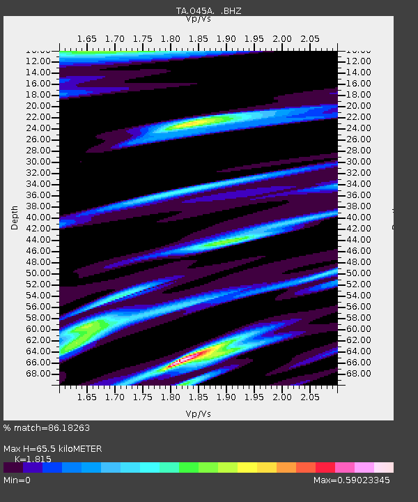
| Estimated Moho Depth: |
65.5 km |
| Estimated Crust Vp/Vs: |
1.82 |
| Assumed Crust Vp: |
6.498 km/s |
| Estimated Crust Vs: |
3.58 km/s |
| Estimated Crust Poisson's Ratio: |
0.28 |
|
| Radial Match: |
86.18263 % |
| Radial Bump: |
245 |
| Transverse Match: |
59.7945 % |
| Transverse Bump: |
400 |
| SOD ConfigId: |
458385 |
| Insert Time: |
2012-10-16 09:14:35.726 +0000 |
| GWidth: |
2.5 |
| Max Bumps: |
400 |
| Tol: |
0.001 |
|
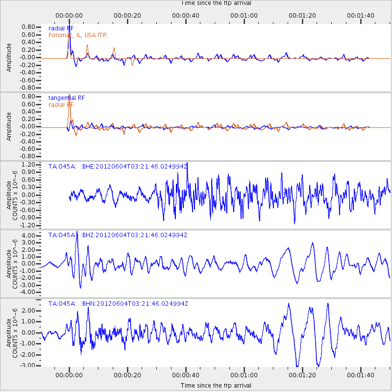
Signal To Noise
| Channel | StoN | STA | LTA |
| TA:O45A: :BHZ:20120604T03:21:46.024994Z | 11.823875 | 1.95511E-6 | 1.6535273E-7 |
| TA:O45A: :BHN:20120604T03:21:46.024994Z | 4.19028 | 9.2738475E-7 | 2.2131809E-7 |
| TA:O45A: :BHE:20120604T03:21:46.024994Z | 2.2659264 | 3.7886483E-7 | 1.6720085E-7 |
| Arrivals |
| Ps | 8.9 SECOND |
| PpPs | 26 SECOND |
| PsPs/PpSs | 35 SECOND |


