You are here: Home > Network List > TA - USArray Transportable Network (new EarthScope stations) Stations List
> Station T47A Sharon Grove, KY, USA > Earthquake Result Viewer
T47A Sharon Grove, KY, USA - Earthquake Result Viewer
| Earthquake location: |
South Of Panama |
| Earthquake latitude/longitude: |
5.5/-82.6 |
| Earthquake time(UTC): |
2012/06/04 (156) 03:15:24 GMT |
| Earthquake Depth: |
7.0 km |
| Earthquake Magnitude: |
5.8 MB, 5.8 MS, 6.3 MW, 6.1 MW |
| Earthquake Catalog/Contributor: |
WHDF/NEIC |
|
| Network: |
TA USArray Transportable Network (new EarthScope stations) |
| Station: |
T47A Sharon Grove, KY, USA |
| Lat/Lon: |
36.99 N/87.11 W |
| Elevation: |
217 m |
|
| Distance: |
31.6 deg |
| Az: |
353.05 deg |
| Baz: |
171.348 deg |
| Ray Param: |
0.079011165 |
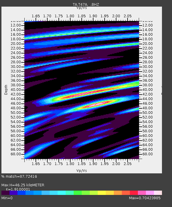
| Estimated Moho Depth: |
46.25 km |
| Estimated Crust Vp/Vs: |
1.91 |
| Assumed Crust Vp: |
6.444 km/s |
| Estimated Crust Vs: |
3.374 km/s |
| Estimated Crust Poisson's Ratio: |
0.31 |
|
| Radial Match: |
87.72416 % |
| Radial Bump: |
324 |
| Transverse Match: |
65.32738 % |
| Transverse Bump: |
400 |
| SOD ConfigId: |
458385 |
| Insert Time: |
2012-10-16 09:15:50.851 +0000 |
| GWidth: |
2.5 |
| Max Bumps: |
400 |
| Tol: |
0.001 |
|
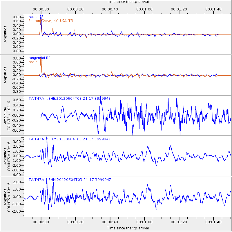
Signal To Noise
| Channel | StoN | STA | LTA |
| TA:T47A: :BHZ:20120604T03:21:17.399994Z | 13.828835 | 1.5591988E-6 | 1.1274984E-7 |
| TA:T47A: :BHN:20120604T03:21:17.399994Z | 9.354949 | 1.0215604E-6 | 1.09199995E-7 |
| TA:T47A: :BHE:20120604T03:21:17.399994Z | 2.7442007 | 3.4630813E-7 | 1.2619635E-7 |
| Arrivals |
| Ps | 7.0 SECOND |
| PpPs | 19 SECOND |
| PsPs/PpSs | 26 SECOND |


