You are here: Home > Network List > TA - USArray Transportable Network (new EarthScope stations) Stations List
> Station U48A Cassie Pea, Portland, TN, USA > Earthquake Result Viewer
U48A Cassie Pea, Portland, TN, USA - Earthquake Result Viewer
| Earthquake location: |
South Of Panama |
| Earthquake latitude/longitude: |
5.5/-82.6 |
| Earthquake time(UTC): |
2012/06/04 (156) 03:15:24 GMT |
| Earthquake Depth: |
7.0 km |
| Earthquake Magnitude: |
5.8 MB, 5.8 MS, 6.3 MW, 6.1 MW |
| Earthquake Catalog/Contributor: |
WHDF/NEIC |
|
| Network: |
TA USArray Transportable Network (new EarthScope stations) |
| Station: |
U48A Cassie Pea, Portland, TN, USA |
| Lat/Lon: |
36.51 N/86.54 W |
| Elevation: |
268 m |
|
| Distance: |
31.1 deg |
| Az: |
353.784 deg |
| Baz: |
172.312 deg |
| Ray Param: |
0.07916956 |
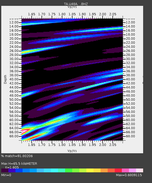
| Estimated Moho Depth: |
65.5 km |
| Estimated Crust Vp/Vs: |
1.61 |
| Assumed Crust Vp: |
6.444 km/s |
| Estimated Crust Vs: |
4.015 km/s |
| Estimated Crust Poisson's Ratio: |
0.18 |
|
| Radial Match: |
91.80206 % |
| Radial Bump: |
221 |
| Transverse Match: |
64.23986 % |
| Transverse Bump: |
400 |
| SOD ConfigId: |
458385 |
| Insert Time: |
2012-10-16 09:16:20.640 +0000 |
| GWidth: |
2.5 |
| Max Bumps: |
400 |
| Tol: |
0.001 |
|
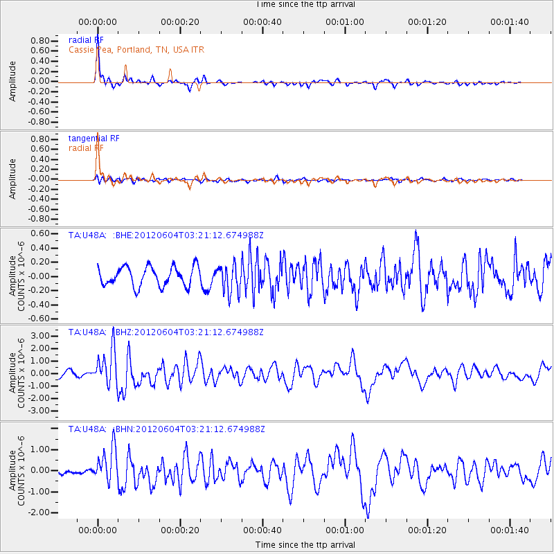
Signal To Noise
| Channel | StoN | STA | LTA |
| TA:U48A: :BHZ:20120604T03:21:12.674988Z | 9.060948 | 1.4551757E-6 | 1.605986E-7 |
| TA:U48A: :BHN:20120604T03:21:12.674988Z | 7.0930004 | 8.390246E-7 | 1.182891E-7 |
| TA:U48A: :BHE:20120604T03:21:12.674988Z | 1.4727519 | 1.991647E-7 | 1.3523304E-7 |
| Arrivals |
| Ps | 6.7 SECOND |
| PpPs | 24 SECOND |
| PsPs/PpSs | 31 SECOND |


