You are here: Home > Network List > TA - USArray Transportable Network (new EarthScope stations) Stations List
> Station T52A Hallie, KY, USA > Earthquake Result Viewer
T52A Hallie, KY, USA - Earthquake Result Viewer
| Earthquake location: |
South Of Panama |
| Earthquake latitude/longitude: |
5.5/-82.6 |
| Earthquake time(UTC): |
2012/06/04 (156) 03:15:24 GMT |
| Earthquake Depth: |
7.0 km |
| Earthquake Magnitude: |
5.8 MB, 5.8 MS, 6.3 MW, 6.1 MW |
| Earthquake Catalog/Contributor: |
WHDF/NEIC |
|
| Network: |
TA USArray Transportable Network (new EarthScope stations) |
| Station: |
T52A Hallie, KY, USA |
| Lat/Lon: |
37.11 N/82.99 W |
| Elevation: |
436 m |
|
| Distance: |
31.5 deg |
| Az: |
359.353 deg |
| Baz: |
179.195 deg |
| Ray Param: |
0.079068914 |
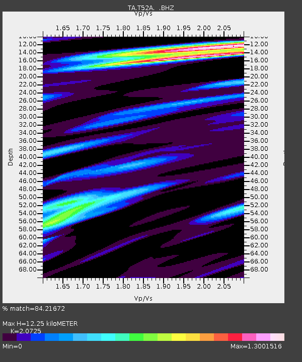
| Estimated Moho Depth: |
12.25 km |
| Estimated Crust Vp/Vs: |
2.07 |
| Assumed Crust Vp: |
6.476 km/s |
| Estimated Crust Vs: |
3.125 km/s |
| Estimated Crust Poisson's Ratio: |
0.35 |
|
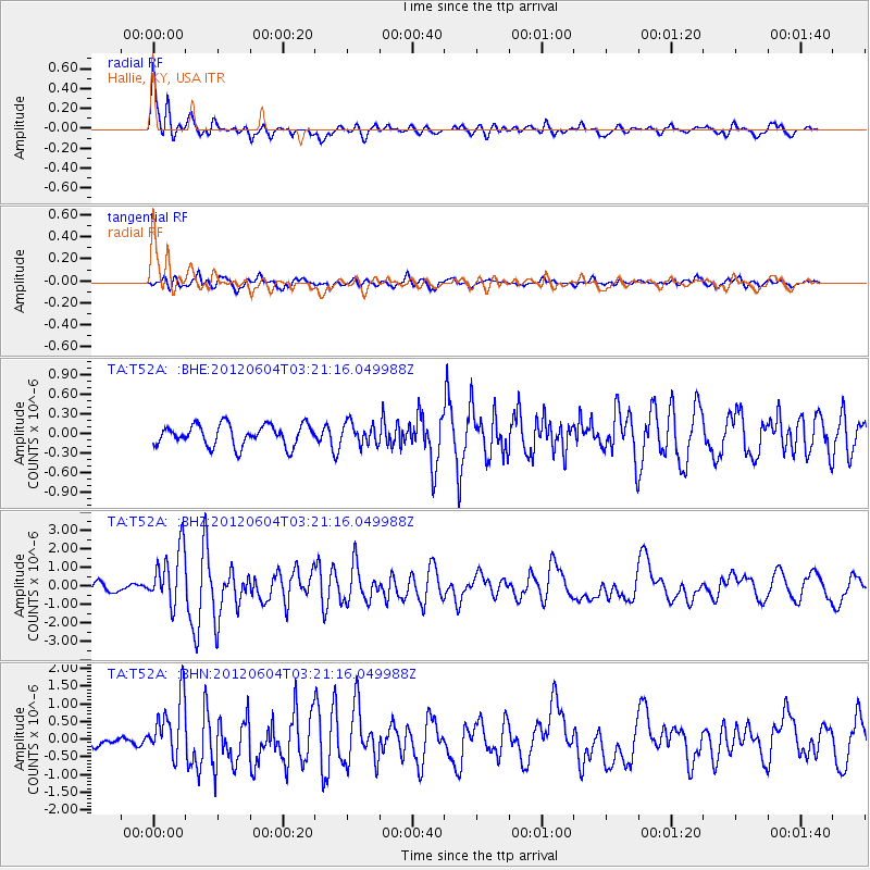
| Radial Match: |
84.21672 % |
| Radial Bump: |
400 |
| Transverse Match: |
70.21494 % |
| Transverse Bump: |
400 |
| SOD ConfigId: |
458385 |
| Insert Time: |
2012-10-16 09:17:13.854 +0000 |
| GWidth: |
2.5 |
| Max Bumps: |
400 |
| Tol: |
0.001 |
|
Signal To Noise
| Channel | StoN | STA | LTA |
| TA:T52A: :BHZ:20120604T03:21:16.049988Z | 6.1623197 | 1.5242275E-6 | 2.4734638E-7 |
| TA:T52A: :BHN:20120604T03:21:16.049988Z | 8.994531 | 8.446807E-7 | 9.391049E-8 |
| TA:T52A: :BHE:20120604T03:21:16.049988Z | 1.0002806 | 1.6103851E-7 | 1.6099334E-7 |
| Arrivals |
| Ps | 2.2 SECOND |
| PpPs | 5.4 SECOND |
| PsPs/PpSs | 7.6 SECOND |


