You are here: Home > Network List > TA - USArray Transportable Network (new EarthScope stations) Stations List
> Station L04D Klamath Falls, OR, USA > Earthquake Result Viewer
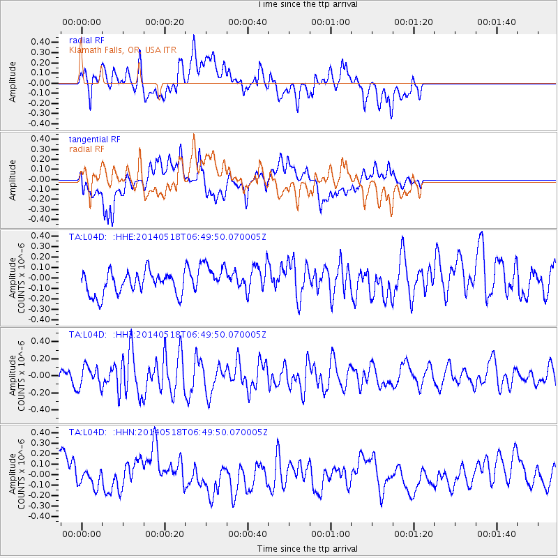
L04D Klamath Falls, OR, USA - Earthquake Result Viewer
*The percent match for this event was below the threshold and hence no stack was calculated.
| Earthquake location: |
Samoa Islands Region |
| Earthquake latitude/longitude: |
-14.9/-175.6 |
| Earthquake time(UTC): |
2014/05/18 (138) 06:38:41 GMT |
| Earthquake Depth: |
26 km |
| Earthquake Magnitude: |
5.6 MW |
| Earthquake Catalog/Contributor: |
ISC/ISC |
|
| Network: |
TA USArray Transportable Network (new EarthScope stations) |
| Station: |
L04D Klamath Falls, OR, USA |
| Lat/Lon: |
42.22 N/122.30 W |
| Elevation: |
1437 m |
|
| Distance: |
75.1 deg |
| Az: |
38.069 deg |
| Baz: |
233.359 deg |
| Ray Param: |
$rayparam |
*The percent match for this event was below the threshold and hence was not used in the summary stack. |
|
| Radial Match: |
57.755997 % |
| Radial Bump: |
400 |
| Transverse Match: |
64.79839 % |
| Transverse Bump: |
400 |
| SOD ConfigId: |
3390531 |
| Insert Time: |
2019-04-11 22:58:38.742 +0000 |
| GWidth: |
2.5 |
| Max Bumps: |
400 |
| Tol: |
0.001 |
|
Signal To Noise
| Channel | StoN | STA | LTA |
| TA:L04D: :HHZ:20140518T06:49:50.070005Z | 1.7073861 | 1.2129604E-7 | 7.104195E-8 |
| TA:L04D: :HHN:20140518T06:49:50.070005Z | 0.5662603 | 7.3184545E-8 | 1.2924188E-7 |
| TA:L04D: :HHE:20140518T06:49:50.070005Z | 1.4686426 | 1.5536659E-7 | 1.0578924E-7 |
| Arrivals |
| Ps | |
| PpPs | |
| PsPs/PpSs | |


