You are here: Home > Network List > G - GEOSCOPE Stations List
> Station SEY Seymchan, URSS > Earthquake Result Viewer
SEY Seymchan, URSS - Earthquake Result Viewer
| Earthquake location: |
Minahassa Peninsula, Sulawesi |
| Earthquake latitude/longitude: |
1.2/122.8 |
| Earthquake time(UTC): |
1991/06/20 (171) 05:18:52 GMT |
| Earthquake Depth: |
33 km |
| Earthquake Magnitude: |
6.2 MB, 7.1 MS, 7.2 UNKNOWN |
| Earthquake Catalog/Contributor: |
WHDF/NEIC |
|
| Network: |
G GEOSCOPE |
| Station: |
SEY Seymchan, URSS |
| Lat/Lon: |
62.93 N/152.37 E |
| Elevation: |
206 m |
|
| Distance: |
65.4 deg |
| Az: |
14.39 deg |
| Baz: |
212.898 deg |
| Ray Param: |
0.058217894 |
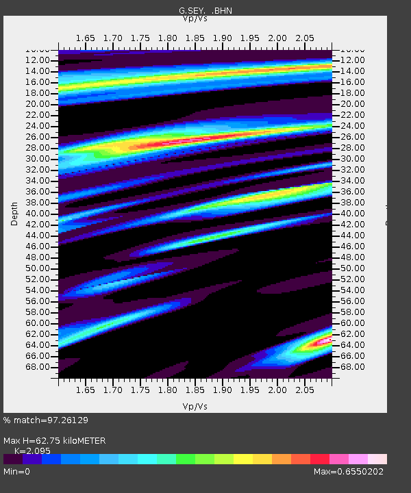
| Estimated Moho Depth: |
62.75 km |
| Estimated Crust Vp/Vs: |
2.10 |
| Assumed Crust Vp: |
6.577 km/s |
| Estimated Crust Vs: |
3.139 km/s |
| Estimated Crust Poisson's Ratio: |
0.35 |
|
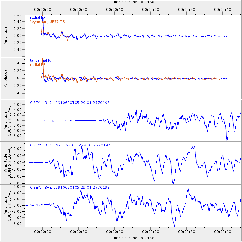
| Radial Match: |
97.26129 % |
| Radial Bump: |
351 |
| Transverse Match: |
87.2376 % |
| Transverse Bump: |
400 |
| SOD ConfigId: |
4480 |
| Insert Time: |
2010-02-26 23:58:38.753 +0000 |
| GWidth: |
2.5 |
| Max Bumps: |
400 |
| Tol: |
0.001 |
|
Signal To Noise
| Channel | StoN | STA | LTA |
| G:SEY: :BHN:19910620T05:29:01.257019Z | 3.388007 | 5.692853E-7 | 1.6802956E-7 |
| G:SEY: :BHE:19910620T05:29:01.257019Z | 4.8068523 | 2.8812002E-7 | 5.993944E-8 |
| G:SEY: :BHZ:19910620T05:29:01.257019Z | 3.4015846 | 1.9598025E-7 | 5.7614397E-8 |
| Arrivals |
| Ps | 11 SECOND |
| PpPs | 28 SECOND |
| PsPs/PpSs | 39 SECOND |


