You are here: Home > Network List > G - GEOSCOPE Stations List
> Station SEY Seymchan, URSS > Earthquake Result Viewer
SEY Seymchan, URSS - Earthquake Result Viewer
| Earthquake location: |
Southern Sumatra, Indonesia |
| Earthquake latitude/longitude: |
-1.1/99.9 |
| Earthquake time(UTC): |
1991/07/02 (183) 05:14:30 GMT |
| Earthquake Depth: |
54 km |
| Earthquake Magnitude: |
5.9 MB, 6.2 UNKNOWN |
| Earthquake Catalog/Contributor: |
WHDF/NEIC |
|
| Network: |
G GEOSCOPE |
| Station: |
SEY Seymchan, URSS |
| Lat/Lon: |
62.93 N/152.37 E |
| Elevation: |
206 m |
|
| Distance: |
74.8 deg |
| Az: |
22.072 deg |
| Baz: |
235.214 deg |
| Ray Param: |
0.051953584 |
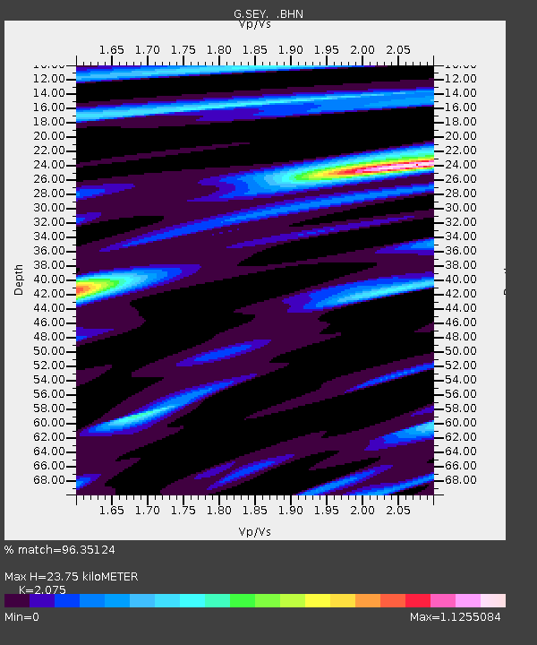
| Estimated Moho Depth: |
23.75 km |
| Estimated Crust Vp/Vs: |
2.08 |
| Assumed Crust Vp: |
6.577 km/s |
| Estimated Crust Vs: |
3.169 km/s |
| Estimated Crust Poisson's Ratio: |
0.35 |
|
| Radial Match: |
96.35124 % |
| Radial Bump: |
400 |
| Transverse Match: |
92.292404 % |
| Transverse Bump: |
400 |
| SOD ConfigId: |
4480 |
| Insert Time: |
2010-02-26 23:58:40.069 +0000 |
| GWidth: |
2.5 |
| Max Bumps: |
400 |
| Tol: |
0.001 |
|
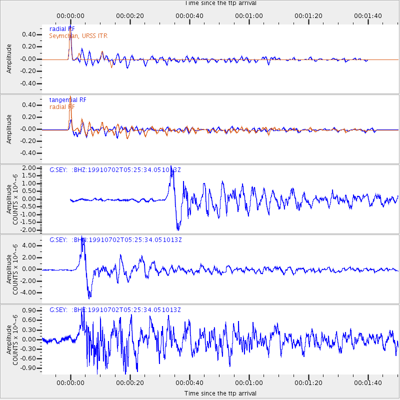
Signal To Noise
| Channel | StoN | STA | LTA |
| G:SEY: :BHN:19910702T05:25:34.051013Z | 52.28726 | 2.1797873E-6 | 4.1688686E-8 |
| G:SEY: :BHE:19910702T05:25:34.051013Z | 6.0863 | 3.4985584E-7 | 5.748252E-8 |
| G:SEY: :BHZ:19910702T05:25:34.051013Z | 18.3973 | 8.5091153E-7 | 4.6251973E-8 |
| Arrivals |
| Ps | 4.0 SECOND |
| PpPs | 11 SECOND |
| PsPs/PpSs | 15 SECOND |


