You are here: Home > Network List > G - GEOSCOPE Stations List
> Station SEY Seymchan, URSS > Earthquake Result Viewer
SEY Seymchan, URSS - Earthquake Result Viewer
| Earthquake location: |
North Of Halmahera, Indonesia |
| Earthquake latitude/longitude: |
3.0/128.5 |
| Earthquake time(UTC): |
1991/07/21 (202) 22:59:10 GMT |
| Earthquake Depth: |
40 km |
| Earthquake Magnitude: |
5.7 MB, 5.3 MS |
| Earthquake Catalog/Contributor: |
WHDF/NEIC |
|
| Network: |
G GEOSCOPE |
| Station: |
SEY Seymchan, URSS |
| Lat/Lon: |
62.93 N/152.37 E |
| Elevation: |
206 m |
|
| Distance: |
62.4 deg |
| Az: |
12.087 deg |
| Baz: |
207.201 deg |
| Ray Param: |
0.060203854 |
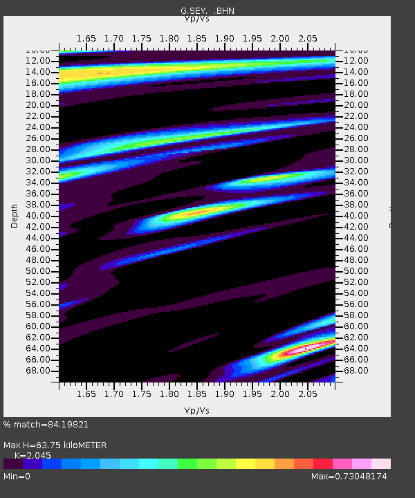
| Estimated Moho Depth: |
63.75 km |
| Estimated Crust Vp/Vs: |
2.05 |
| Assumed Crust Vp: |
6.577 km/s |
| Estimated Crust Vs: |
3.216 km/s |
| Estimated Crust Poisson's Ratio: |
0.34 |
|
| Radial Match: |
84.19821 % |
| Radial Bump: |
400 |
| Transverse Match: |
80.873405 % |
| Transverse Bump: |
400 |
| SOD ConfigId: |
4480 |
| Insert Time: |
2010-02-26 23:58:48.841 +0000 |
| GWidth: |
2.5 |
| Max Bumps: |
400 |
| Tol: |
0.001 |
|
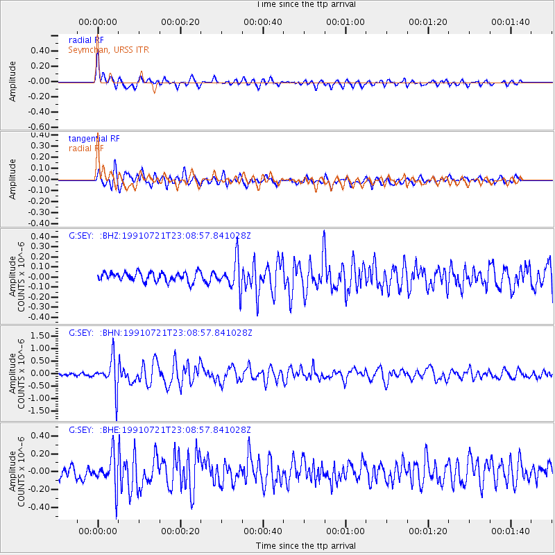
Signal To Noise
| Channel | StoN | STA | LTA |
| G:SEY: :BHN:19910721T23:08:57.841028Z | 10.02664 | 6.4383954E-7 | 6.421289E-8 |
| G:SEY: :BHE:19910721T23:08:57.841028Z | 3.8240087 | 1.8387786E-7 | 4.8085106E-8 |
| G:SEY: :BHZ:19910721T23:08:57.841028Z | 3.3537261 | 1.5003698E-7 | 4.4737398E-8 |
| Arrivals |
| Ps | 11 SECOND |
| PpPs | 28 SECOND |
| PsPs/PpSs | 39 SECOND |


