You are here: Home > Network List > G - GEOSCOPE Stations List
> Station SEY Seymchan, URSS > Earthquake Result Viewer
SEY Seymchan, URSS - Earthquake Result Viewer
| Earthquake location: |
Southeast Of Loyalty Islands |
| Earthquake latitude/longitude: |
-23.4/171.1 |
| Earthquake time(UTC): |
1991/12/11 (345) 20:39:38 GMT |
| Earthquake Depth: |
34 km |
| Earthquake Magnitude: |
5.6 MB, 6.5 MS, 6.3 UNKNOWN |
| Earthquake Catalog/Contributor: |
WHDF/NEIC |
|
| Network: |
G GEOSCOPE |
| Station: |
SEY Seymchan, URSS |
| Lat/Lon: |
62.93 N/152.37 E |
| Elevation: |
206 m |
|
| Distance: |
87.3 deg |
| Az: |
351.559 deg |
| Baz: |
162.852 deg |
| Ray Param: |
0.043376267 |
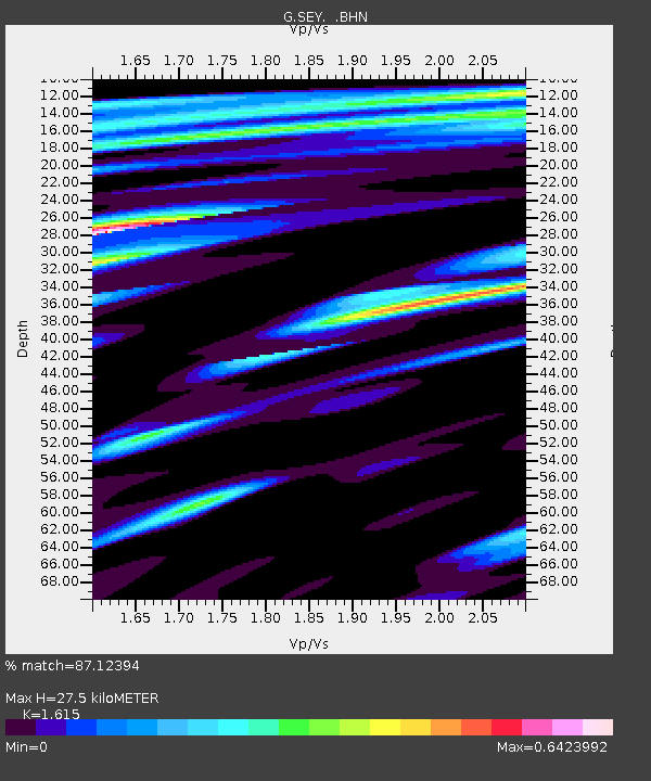
| Estimated Moho Depth: |
27.5 km |
| Estimated Crust Vp/Vs: |
1.62 |
| Assumed Crust Vp: |
6.577 km/s |
| Estimated Crust Vs: |
4.072 km/s |
| Estimated Crust Poisson's Ratio: |
0.19 |
|
| Radial Match: |
87.12394 % |
| Radial Bump: |
354 |
| Transverse Match: |
69.33877 % |
| Transverse Bump: |
400 |
| SOD ConfigId: |
4480 |
| Insert Time: |
2010-02-26 23:58:50.358 +0000 |
| GWidth: |
2.5 |
| Max Bumps: |
400 |
| Tol: |
0.001 |
|
Signal To Noise
| Channel | StoN | STA | LTA |
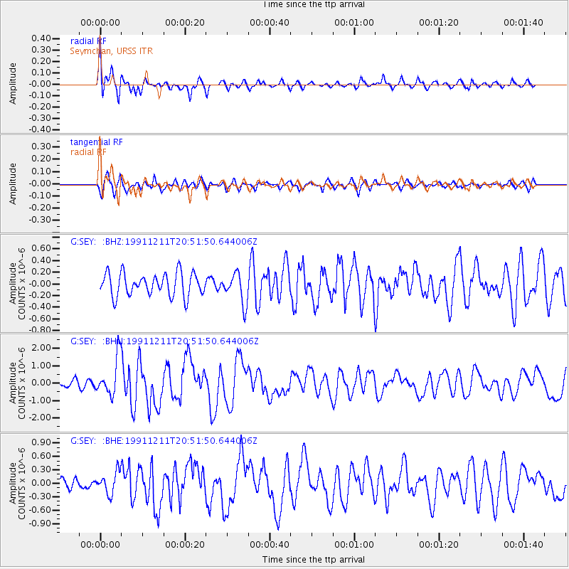
| G:SEY: :BHN:19911211T20:51:50.644006Z | 4.7382526 | 1.1283944E-6 | 2.3814569E-7 |
| G:SEY: :BHE:19911211T20:51:50.644006Z | 1.5413656 | 2.4946E-7 | 1.6184349E-7 |
| G:SEY: :BHZ:19911211T20:51:50.644006Z | 1.3881317 | 2.6946057E-7 | 1.9411743E-7 |
| Arrivals |
| Ps | 2.6 SECOND |
| PpPs | 11 SECOND |
| PsPs/PpSs | 13 SECOND |


