You are here: Home > Network List > G - GEOSCOPE Stations List
> Station SEY Seymchan, URSS > Earthquake Result Viewer
SEY Seymchan, URSS - Earthquake Result Viewer
| Earthquake location: |
Southwest Of Sumatra, Indonesia |
| Earthquake latitude/longitude: |
-2.2/92.3 |
| Earthquake time(UTC): |
1990/10/15 (288) 01:35:44 GMT |
| Earthquake Depth: |
34 km |
| Earthquake Magnitude: |
5.9 MB, 6.5 MS |
| Earthquake Catalog/Contributor: |
WHDF/NEIC |
|
| Network: |
G GEOSCOPE |
| Station: |
SEY Seymchan, URSS |
| Lat/Lon: |
62.93 N/152.37 E |
| Elevation: |
206 m |
|
| Distance: |
78.8 deg |
| Az: |
23.842 deg |
| Baz: |
242.002 deg |
| Ray Param: |
0.049341954 |
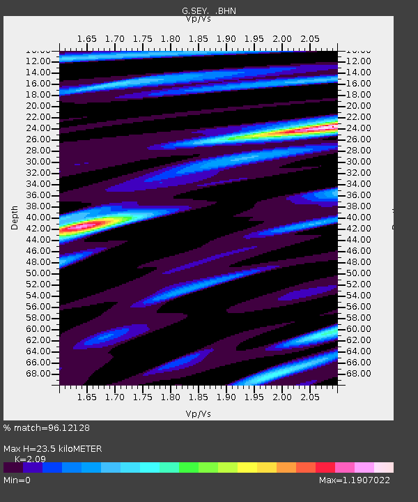
| Estimated Moho Depth: |
23.5 km |
| Estimated Crust Vp/Vs: |
2.09 |
| Assumed Crust Vp: |
6.577 km/s |
| Estimated Crust Vs: |
3.147 km/s |
| Estimated Crust Poisson's Ratio: |
0.35 |
|
| Radial Match: |
96.12128 % |
| Radial Bump: |
400 |
| Transverse Match: |
90.56187 % |
| Transverse Bump: |
400 |
| SOD ConfigId: |
16938 |
| Insert Time: |
2010-02-26 23:58:54.625 +0000 |
| GWidth: |
2.5 |
| Max Bumps: |
400 |
| Tol: |
0.001 |
|
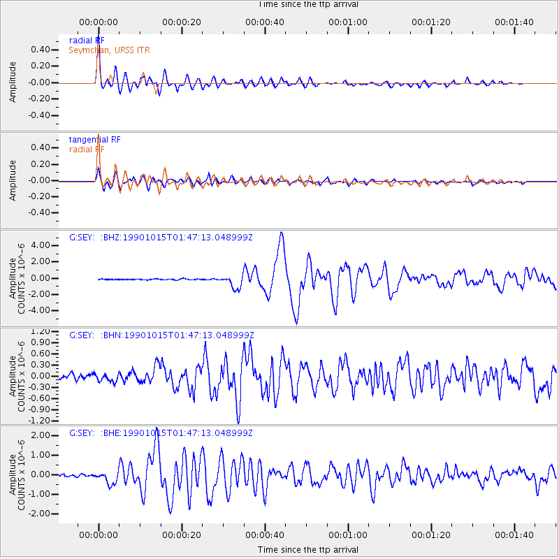
Signal To Noise
| Channel | StoN | STA | LTA |
| G:SEY: :BHN:19901015T01:47:13.048999Z | 0.8141413 | 9.1704926E-8 | 1.12640066E-7 |
| G:SEY: :BHE:19901015T01:47:13.048999Z | 8.303136 | 3.1771611E-7 | 3.8264595E-8 |
| G:SEY: :BHZ:19901015T01:47:13.048999Z | 15.610144 | 8.3436595E-7 | 5.345024E-8 |
| Arrivals |
| Ps | 4.0 SECOND |
| PpPs | 11 SECOND |
| PsPs/PpSs | 15 SECOND |


