You are here: Home > Network List > G - GEOSCOPE Stations List
> Station SEY Seymchan, URSS > Earthquake Result Viewer
SEY Seymchan, URSS - Earthquake Result Viewer
| Earthquake location: |
Southern Iran |
| Earthquake latitude/longitude: |
28.2/55.5 |
| Earthquake time(UTC): |
1990/11/06 (310) 18:45:54 GMT |
| Earthquake Depth: |
25 km |
| Earthquake Magnitude: |
6.2 MB, 6.8 MS, 6.7 UNKNOWN |
| Earthquake Catalog/Contributor: |
WHDF/NEIC |
|
| Network: |
G GEOSCOPE |
| Station: |
SEY Seymchan, URSS |
| Lat/Lon: |
62.93 N/152.37 E |
| Elevation: |
206 m |
|
| Distance: |
68.3 deg |
| Az: |
29.261 deg |
| Baz: |
289.477 deg |
| Ray Param: |
0.056366704 |
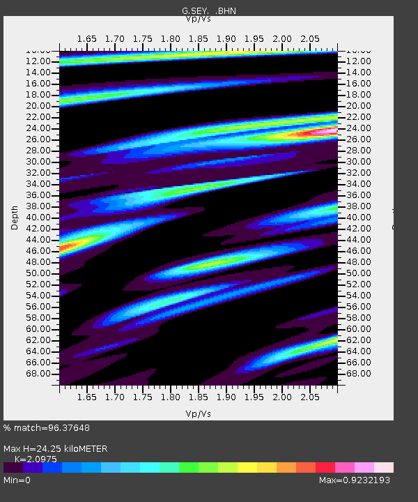
| Estimated Moho Depth: |
24.25 km |
| Estimated Crust Vp/Vs: |
2.10 |
| Assumed Crust Vp: |
6.577 km/s |
| Estimated Crust Vs: |
3.136 km/s |
| Estimated Crust Poisson's Ratio: |
0.35 |
|
| Radial Match: |
96.37648 % |
| Radial Bump: |
366 |
| Transverse Match: |
86.641106 % |
| Transverse Bump: |
400 |
| SOD ConfigId: |
16938 |
| Insert Time: |
2010-02-26 23:58:56.094 +0000 |
| GWidth: |
2.5 |
| Max Bumps: |
400 |
| Tol: |
0.001 |
|
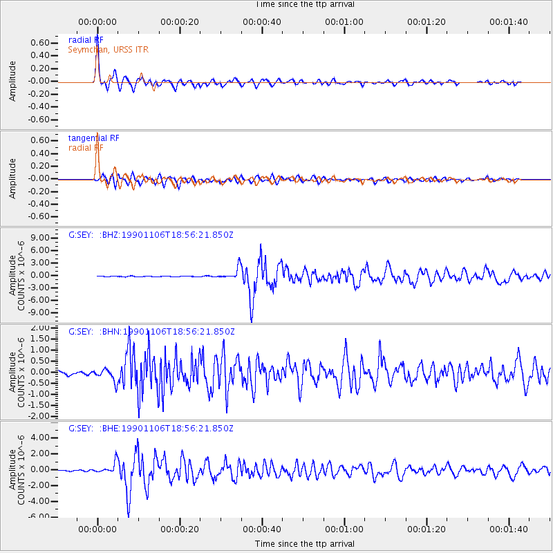
Signal To Noise
| Channel | StoN | STA | LTA |
| G:SEY: :BHN:19901106T18:56:21.850Z | 2.3025043 | 2.8668435E-7 | 1.2450981E-7 |
| G:SEY: :BHE:19901106T18:56:21.850Z | 16.938356 | 7.504234E-7 | 4.4303196E-8 |
| G:SEY: :BHZ:19901106T18:56:21.850Z | 15.741552 | 1.4554848E-6 | 9.246133E-8 |
| Arrivals |
| Ps | 4.2 SECOND |
| PpPs | 11 SECOND |
| PsPs/PpSs | 15 SECOND |


