You are here: Home > Network List > G - GEOSCOPE Stations List
> Station SEY Seymchan, URSS > Earthquake Result Viewer
SEY Seymchan, URSS - Earthquake Result Viewer
| Earthquake location: |
Minahassa Peninsula, Sulawesi |
| Earthquake latitude/longitude: |
0.9/122.6 |
| Earthquake time(UTC): |
1991/08/08 (220) 02:09:47 GMT |
| Earthquake Depth: |
33 km |
| Earthquake Magnitude: |
5.8 MB, 6.4 MS |
| Earthquake Catalog/Contributor: |
WHDF/NEIC |
|
| Network: |
G GEOSCOPE |
| Station: |
SEY Seymchan, URSS |
| Lat/Lon: |
62.93 N/152.37 E |
| Elevation: |
206 m |
|
| Distance: |
65.7 deg |
| Az: |
14.436 deg |
| Baz: |
213.017 deg |
| Ray Param: |
0.05804022 |
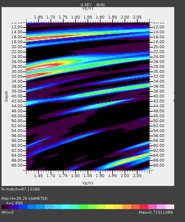
| Estimated Moho Depth: |
28.25 km |
| Estimated Crust Vp/Vs: |
1.65 |
| Assumed Crust Vp: |
6.577 km/s |
| Estimated Crust Vs: |
3.974 km/s |
| Estimated Crust Poisson's Ratio: |
0.21 |
|
| Radial Match: |
97.10368 % |
| Radial Bump: |
347 |
| Transverse Match: |
90.2802 % |
| Transverse Bump: |
400 |
| SOD ConfigId: |
16938 |
| Insert Time: |
2010-02-26 23:59:00.778 +0000 |
| GWidth: |
2.5 |
| Max Bumps: |
400 |
| Tol: |
0.001 |
|
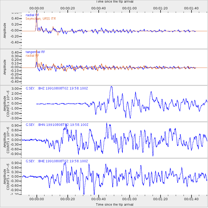
Signal To Noise
| Channel | StoN | STA | LTA |
| G:SEY: :BHN:19910808T02:19:58.100Z | 1.3205687 | 3.8252903E-8 | 2.8966992E-8 |
| G:SEY: :BHE:19910808T02:19:58.100Z | 1.463594 | 5.7421556E-8 | 3.9233253E-8 |
| G:SEY: :BHZ:19910808T02:19:58.100Z | 4.8645287 | 2.4895726E-7 | 5.1178084E-8 |
| Arrivals |
| Ps | 2.9 SECOND |
| PpPs | 11 SECOND |
| PsPs/PpSs | 14 SECOND |


