You are here: Home > Network List > CI - Caltech Regional Seismic Network Stations List
> Station FUR Furnace Creek, CA, USA > Earthquake Result Viewer
FUR Furnace Creek, CA, USA - Earthquake Result Viewer
| Earthquake location: |
Off East Coast Of Honshu, Japan |
| Earthquake latitude/longitude: |
34.9/141.1 |
| Earthquake time(UTC): |
2012/06/05 (157) 19:31:33 GMT |
| Earthquake Depth: |
15 km |
| Earthquake Magnitude: |
6.2 MB, 6.0 MS, 6.1 MW, 6.1 MW |
| Earthquake Catalog/Contributor: |
WHDF/NEIC |
|
| Network: |
CI Caltech Regional Seismic Network |
| Station: |
FUR Furnace Creek, CA, USA |
| Lat/Lon: |
36.47 N/116.86 W |
| Elevation: |
-37.0 m |
|
| Distance: |
78.5 deg |
| Az: |
53.579 deg |
| Baz: |
304.908 deg |
| Ray Param: |
0.0496024 |
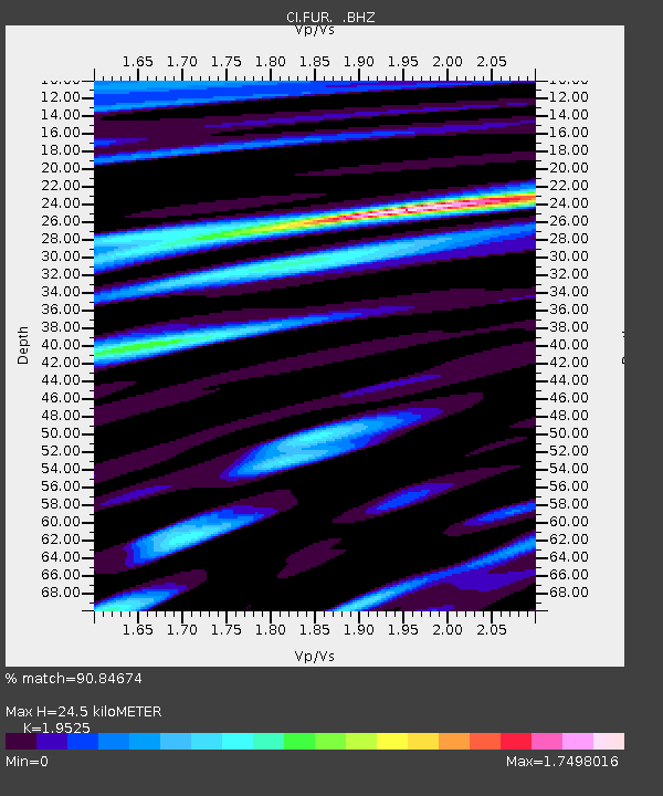
| Estimated Moho Depth: |
24.5 km |
| Estimated Crust Vp/Vs: |
1.95 |
| Assumed Crust Vp: |
6.279 km/s |
| Estimated Crust Vs: |
3.216 km/s |
| Estimated Crust Poisson's Ratio: |
0.32 |
|
| Radial Match: |
90.84674 % |
| Radial Bump: |
400 |
| Transverse Match: |
84.46984 % |
| Transverse Bump: |
400 |
| SOD ConfigId: |
458385 |
| Insert Time: |
2012-10-16 09:51:22.252 +0000 |
| GWidth: |
2.5 |
| Max Bumps: |
400 |
| Tol: |
0.001 |
|

Signal To Noise
| Channel | StoN | STA | LTA |
| CI:FUR: :BHZ:20120605T19:43:02.669983Z | 12.711519 | 1.5185262E-6 | 1.1946064E-7 |
| CI:FUR: :BHN:20120605T19:43:02.669983Z | 1.1677105 | 2.1177875E-7 | 1.8136238E-7 |
| CI:FUR: :BHE:20120605T19:43:02.669983Z | 2.407374 | 4.3377898E-7 | 1.8018763E-7 |
| Arrivals |
| Ps | 3.8 SECOND |
| PpPs | 11 SECOND |
| PsPs/PpSs | 15 SECOND |


