You are here: Home > Network List > G - GEOSCOPE Stations List
> Station SEY Seymchan, URSS > Earthquake Result Viewer
SEY Seymchan, URSS - Earthquake Result Viewer
| Earthquake location: |
Near Coast Of Northern Calif. |
| Earthquake latitude/longitude: |
40.2/-124.3 |
| Earthquake time(UTC): |
1991/08/17 (229) 19:29:40 GMT |
| Earthquake Depth: |
12 km |
| Earthquake Magnitude: |
6.1 MB, 6.0 MS, 6.0 ML |
| Earthquake Catalog/Contributor: |
WHDF/NEIC |
|
| Network: |
G GEOSCOPE |
| Station: |
SEY Seymchan, URSS |
| Lat/Lon: |
62.93 N/152.37 E |
| Elevation: |
206 m |
|
| Distance: |
52.2 deg |
| Az: |
324.894 deg |
| Baz: |
74.233 deg |
| Ray Param: |
0.06691632 |
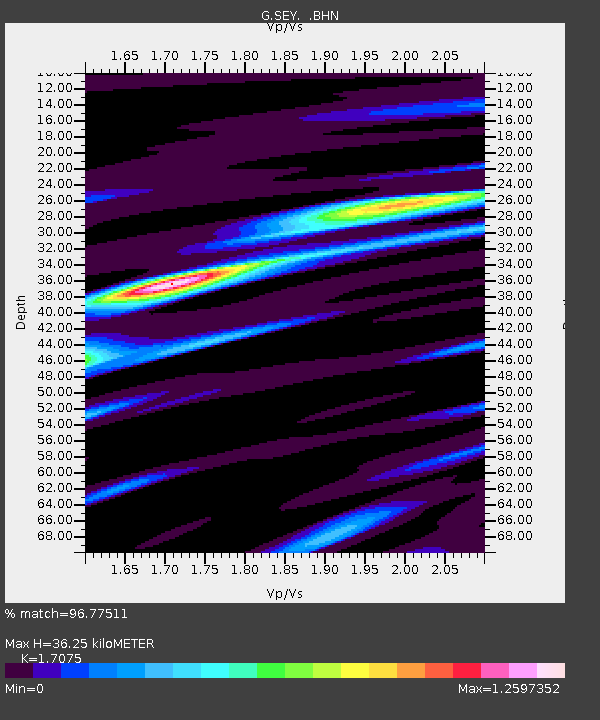
| Estimated Moho Depth: |
36.25 km |
| Estimated Crust Vp/Vs: |
1.71 |
| Assumed Crust Vp: |
6.577 km/s |
| Estimated Crust Vs: |
3.852 km/s |
| Estimated Crust Poisson's Ratio: |
0.24 |
|
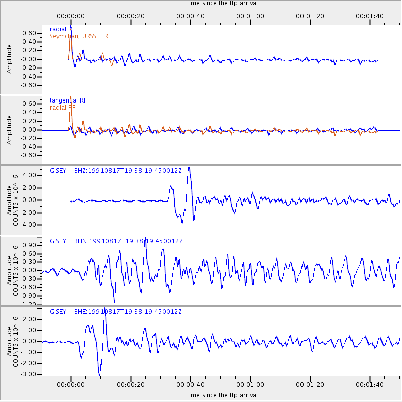
| Radial Match: |
96.77511 % |
| Radial Bump: |
245 |
| Transverse Match: |
82.34089 % |
| Transverse Bump: |
400 |
| SOD ConfigId: |
16938 |
| Insert Time: |
2010-02-26 23:59:05.648 +0000 |
| GWidth: |
2.5 |
| Max Bumps: |
400 |
| Tol: |
0.001 |
|
Signal To Noise
| Channel | StoN | STA | LTA |
| G:SEY: :BHN:19910817T19:38:19.450012Z | 1.9552778 | 1.2663725E-7 | 6.476688E-8 |
| G:SEY: :BHE:19910817T19:38:19.450012Z | 11.164029 | 5.8451934E-7 | 5.2357382E-8 |
| G:SEY: :BHZ:19910817T19:38:19.450012Z | 12.238668 | 1.0391449E-6 | 8.4906695E-8 |
| Arrivals |
| Ps | 4.1 SECOND |
| PpPs | 14 SECOND |
| PsPs/PpSs | 18 SECOND |


