You are here: Home > Network List > G - GEOSCOPE Stations List
> Station SEY Seymchan, URSS > Earthquake Result Viewer
SEY Seymchan, URSS - Earthquake Result Viewer
| Earthquake location: |
Fiji Islands Region |
| Earthquake latitude/longitude: |
-21.0/-178.6 |
| Earthquake time(UTC): |
1991/09/30 (273) 00:21:47 GMT |
| Earthquake Depth: |
580 km |
| Earthquake Magnitude: |
6.0 MB, 6.5 UNKNOWN |
| Earthquake Catalog/Contributor: |
WHDF/NEIC |
|
| Network: |
G GEOSCOPE |
| Station: |
SEY Seymchan, URSS |
| Lat/Lon: |
62.93 N/152.37 E |
| Elevation: |
206 m |
|
| Distance: |
86.7 deg |
| Az: |
347.157 deg |
| Baz: |
152.993 deg |
| Ray Param: |
0.042190537 |
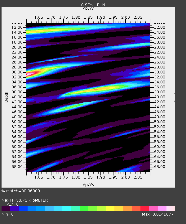
| Estimated Moho Depth: |
30.75 km |
| Estimated Crust Vp/Vs: |
1.60 |
| Assumed Crust Vp: |
6.577 km/s |
| Estimated Crust Vs: |
4.11 km/s |
| Estimated Crust Poisson's Ratio: |
0.18 |
|
| Radial Match: |
90.96009 % |
| Radial Bump: |
400 |
| Transverse Match: |
88.27272 % |
| Transverse Bump: |
400 |
| SOD ConfigId: |
16938 |
| Insert Time: |
2010-02-26 23:59:12.250 +0000 |
| GWidth: |
2.5 |
| Max Bumps: |
400 |
| Tol: |
0.001 |
|
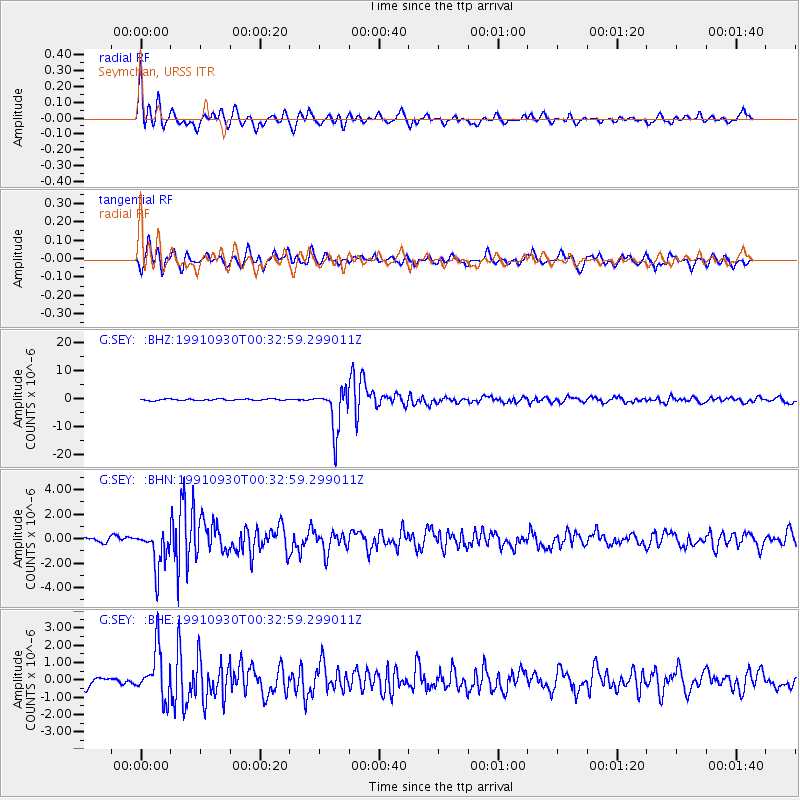
Signal To Noise
| Channel | StoN | STA | LTA |
| G:SEY: :BHN:19910930T00:32:59.299011Z | 6.2770834 | 1.5659616E-6 | 2.494728E-7 |
| G:SEY: :BHE:19910930T00:32:59.299011Z | 5.755436 | 1.413638E-6 | 2.4561788E-7 |
| G:SEY: :BHZ:19910930T00:32:59.299011Z | 28.667618 | 7.6975675E-6 | 2.685109E-7 |
| Arrivals |
| Ps | 2.9 SECOND |
| PpPs | 12 SECOND |
| PsPs/PpSs | 15 SECOND |


