You are here: Home > Network List > G - GEOSCOPE Stations List
> Station SEY Seymchan, URSS > Earthquake Result Viewer
SEY Seymchan, URSS - Earthquake Result Viewer
| Earthquake location: |
Seram, Indonesia |
| Earthquake latitude/longitude: |
-3.2/130.3 |
| Earthquake time(UTC): |
1991/08/11 (223) 14:43:53 GMT |
| Earthquake Depth: |
33 km |
| Earthquake Magnitude: |
5.6 MB, 5.4 MS |
| Earthquake Catalog/Contributor: |
WHDF/NEIC |
|
| Network: |
G GEOSCOPE |
| Station: |
SEY Seymchan, URSS |
| Lat/Lon: |
62.93 N/152.37 E |
| Elevation: |
206 m |
|
| Distance: |
68.0 deg |
| Az: |
10.677 deg |
| Baz: |
203.854 deg |
| Ray Param: |
0.056526683 |
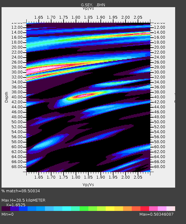
| Estimated Moho Depth: |
28.5 km |
| Estimated Crust Vp/Vs: |
1.65 |
| Assumed Crust Vp: |
6.577 km/s |
| Estimated Crust Vs: |
3.98 km/s |
| Estimated Crust Poisson's Ratio: |
0.21 |
|
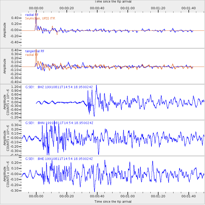
| Radial Match: |
89.50834 % |
| Radial Bump: |
400 |
| Transverse Match: |
80.737885 % |
| Transverse Bump: |
400 |
| SOD ConfigId: |
17000 |
| Insert Time: |
2010-02-26 23:59:13.402 +0000 |
| GWidth: |
2.5 |
| Max Bumps: |
400 |
| Tol: |
0.001 |
|
Signal To Noise
| Channel | StoN | STA | LTA |
| G:SEY: :BHN:19910811T14:54:18.950024Z | 2.557418 | 9.075027E-8 | 3.5485115E-8 |
| G:SEY: :BHE:19910811T14:54:18.950024Z | 1.7126391 | 4.5200228E-8 | 2.6392149E-8 |
| G:SEY: :BHZ:19910811T14:54:18.950024Z | 5.1296597 | 2.7902152E-7 | 5.4393766E-8 |
| Arrivals |
| Ps | 3.0 SECOND |
| PpPs | 11 SECOND |
| PsPs/PpSs | 14 SECOND |


