You are here: Home > Network List > G - GEOSCOPE Stations List
> Station SEY Seymchan, URSS > Earthquake Result Viewer
SEY Seymchan, URSS - Earthquake Result Viewer
| Earthquake location: |
Southern Sumatra, Indonesia |
| Earthquake latitude/longitude: |
-5.8/103.2 |
| Earthquake time(UTC): |
1992/02/06 (037) 01:12:39 GMT |
| Earthquake Depth: |
45 km |
| Earthquake Magnitude: |
5.9 MB, 6.4 MS, 6.3 UNKNOWN |
| Earthquake Catalog/Contributor: |
WHDF/NEIC |
|
| Network: |
G GEOSCOPE |
| Station: |
SEY Seymchan, URSS |
| Lat/Lon: |
62.93 N/152.37 E |
| Elevation: |
206 m |
|
| Distance: |
78.0 deg |
| Az: |
20.744 deg |
| Baz: |
230.39 deg |
| Ray Param: |
0.049885955 |
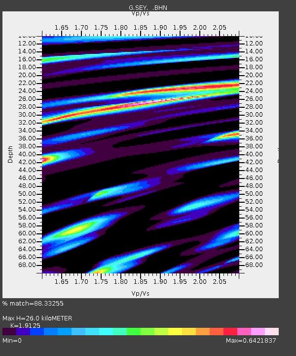
| Estimated Moho Depth: |
26.0 km |
| Estimated Crust Vp/Vs: |
1.91 |
| Assumed Crust Vp: |
6.577 km/s |
| Estimated Crust Vs: |
3.439 km/s |
| Estimated Crust Poisson's Ratio: |
0.31 |
|
| Radial Match: |
88.33255 % |
| Radial Bump: |
400 |
| Transverse Match: |
84.023285 % |
| Transverse Bump: |
400 |
| SOD ConfigId: |
4480 |
| Insert Time: |
2010-02-26 23:59:15.377 +0000 |
| GWidth: |
2.5 |
| Max Bumps: |
400 |
| Tol: |
0.001 |
|
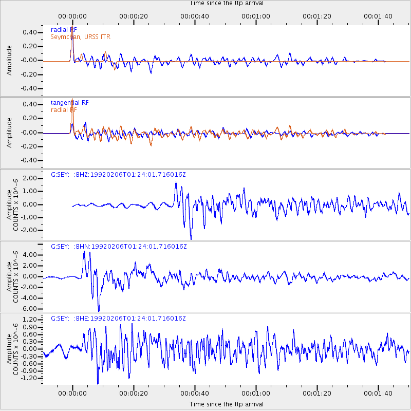
Signal To Noise
| Channel | StoN | STA | LTA |
| G:SEY: :BHN:19920206T01:24:01.716016Z | 13.911292 | 1.5126691E-6 | 1.08736785E-7 |
| G:SEY: :BHE:19920206T01:24:01.716016Z | 1.560342 | 1.9639393E-7 | 1.2586595E-7 |
| G:SEY: :BHZ:19920206T01:24:01.716016Z | 5.9904895 | 5.670367E-7 | 9.4656144E-8 |
| Arrivals |
| Ps | 3.7 SECOND |
| PpPs | 11 SECOND |
| PsPs/PpSs | 15 SECOND |


