T25A Trinidad, CO, USA - Earthquake Result Viewer
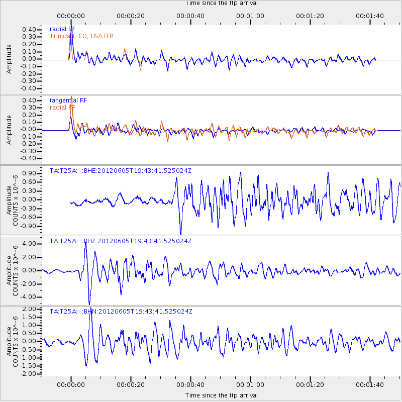
Earthquake location: Off East Coast Of Honshu, Japan
Earthquake latitude/longitude: 34.9/141.1
Earthquake time(UTC): 2012/06/05 (157) 19:31:33 GMT
Earthquake Depth: 15 km
Earthquake Magnitude: 6.2 MB, 6.0 MS, 6.1 MW, 6.1 MW
Earthquake Catalog/Contributor: WHDF/NEIC
Network: TA USArray Transportable Network (new EarthScope stations)
Station: T25A Trinidad, CO, USA
Lat/Lon: 37.14 N/104.41 W
Elevation: 2017 m
Distance: 85.9 deg
Az: 46.824 deg
Baz: 311.436 deg
Ray Param: 0.04440388
Estimated Moho Depth: 54.0 km
Estimated Crust Vp/Vs: 1.61
Assumed Crust Vp: 6.316 km/s
Estimated Crust Vs: 3.929 km/s
Estimated Crust Poisson's Ratio: 0.18
Radial Match: 87.25664 %
Radial Bump: 400
Transverse Match: 87.11803 %
Transverse Bump: 400
SOD ConfigId: 458385
Insert Time: 2012-10-16 10:11:42.736 +0000
GWidth: 2.5
Max Bumps: 400
Tol: 0.001

Signal To Noise

ChannelStoNSTALTA
TA:T25A: :BHZ:20120605T19:43:41.525024Z7.4713711.0114475E-61.3537641E-7
TA:T25A: :BHN:20120605T19:43:41.525024Z2.14790493.1634605E-71.4728123E-7
TA:T25A: :BHE:20120605T19:43:41.525024Z1.07210961.0230145E-79.542071E-8
Arrivals
Ps5.3 SECOND
PpPs22 SECOND
PsPs/PpSs27 SECOND