You are here: Home > Network List > TA - USArray Transportable Network (new EarthScope stations) Stations List
> Station S22A 4UR Ranch, Creede, CO, USA > Earthquake Result Viewer
S22A 4UR Ranch, Creede, CO, USA - Earthquake Result Viewer
| Earthquake location: |
Off East Coast Of Honshu, Japan |
| Earthquake latitude/longitude: |
34.9/141.1 |
| Earthquake time(UTC): |
2012/06/05 (157) 19:31:33 GMT |
| Earthquake Depth: |
15 km |
| Earthquake Magnitude: |
6.2 MB, 6.0 MS, 6.1 MW, 6.1 MW |
| Earthquake Catalog/Contributor: |
WHDF/NEIC |
|
| Network: |
TA USArray Transportable Network (new EarthScope stations) |
| Station: |
S22A 4UR Ranch, Creede, CO, USA |
| Lat/Lon: |
37.75 N/106.83 W |
| Elevation: |
2626 m |
|
| Distance: |
84.1 deg |
| Az: |
47.624 deg |
| Baz: |
310.041 deg |
| Ray Param: |
0.045727264 |
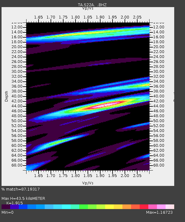
| Estimated Moho Depth: |
43.5 km |
| Estimated Crust Vp/Vs: |
1.91 |
| Assumed Crust Vp: |
6.159 km/s |
| Estimated Crust Vs: |
3.216 km/s |
| Estimated Crust Poisson's Ratio: |
0.31 |
|
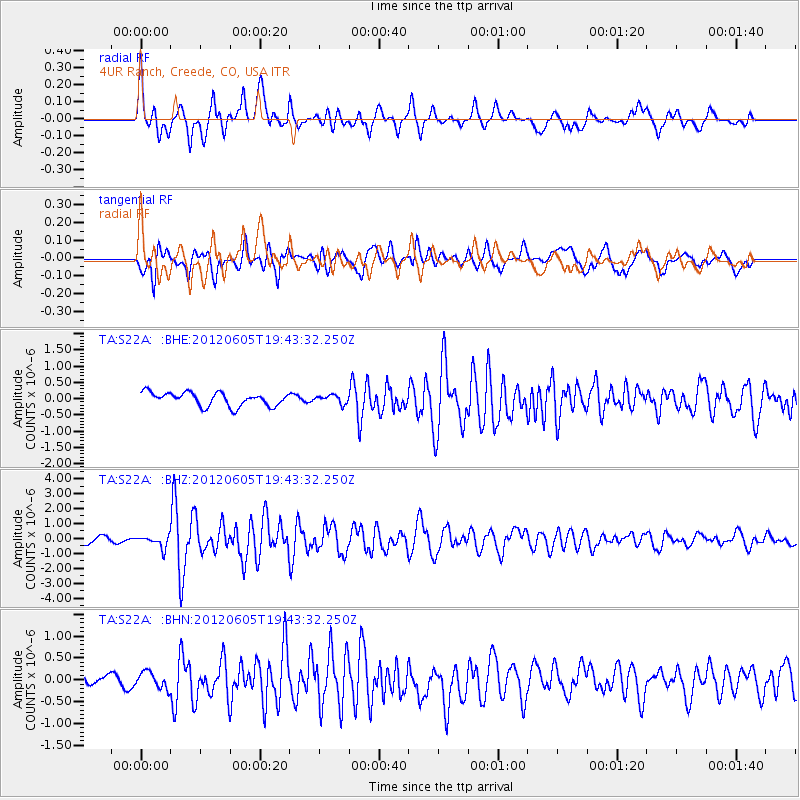
| Radial Match: |
87.19317 % |
| Radial Bump: |
400 |
| Transverse Match: |
75.01736 % |
| Transverse Bump: |
400 |
| SOD ConfigId: |
458385 |
| Insert Time: |
2012-10-16 10:11:54.222 +0000 |
| GWidth: |
2.5 |
| Max Bumps: |
400 |
| Tol: |
0.001 |
|
Signal To Noise
| Channel | StoN | STA | LTA |
| TA:S22A: :BHZ:20120605T19:43:32.250Z | 2.0492501 | 4.067606E-7 | 1.984924E-7 |
| TA:S22A: :BHN:20120605T19:43:32.250Z | 1.0617627 | 1.8891595E-7 | 1.7792672E-7 |
| TA:S22A: :BHE:20120605T19:43:32.250Z | 0.61290026 | 1.2764565E-7 | 2.0826498E-7 |
| Arrivals |
| Ps | 6.6 SECOND |
| PpPs | 20 SECOND |
| PsPs/PpSs | 27 SECOND |


