You are here: Home > Network List > G - GEOSCOPE Stations List
> Station SEY Seymchan, URSS > Earthquake Result Viewer
SEY Seymchan, URSS - Earthquake Result Viewer
| Earthquake location: |
Minahassa Peninsula, Sulawesi |
| Earthquake latitude/longitude: |
1.2/122.5 |
| Earthquake time(UTC): |
1992/04/16 (107) 08:00:55 GMT |
| Earthquake Depth: |
41 km |
| Earthquake Magnitude: |
5.7 MB, 5.6 MS |
| Earthquake Catalog/Contributor: |
WHDF/NEIC |
|
| Network: |
G GEOSCOPE |
| Station: |
SEY Seymchan, URSS |
| Lat/Lon: |
62.93 N/152.37 E |
| Elevation: |
206 m |
|
| Distance: |
65.5 deg |
| Az: |
14.479 deg |
| Baz: |
213.124 deg |
| Ray Param: |
0.058153994 |
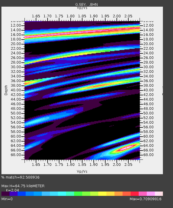
| Estimated Moho Depth: |
64.75 km |
| Estimated Crust Vp/Vs: |
2.04 |
| Assumed Crust Vp: |
6.577 km/s |
| Estimated Crust Vs: |
3.224 km/s |
| Estimated Crust Poisson's Ratio: |
0.34 |
|
| Radial Match: |
92.588936 % |
| Radial Bump: |
381 |
| Transverse Match: |
74.71857 % |
| Transverse Bump: |
400 |
| SOD ConfigId: |
4480 |
| Insert Time: |
2010-02-26 23:59:31.593 +0000 |
| GWidth: |
2.5 |
| Max Bumps: |
400 |
| Tol: |
0.001 |
|
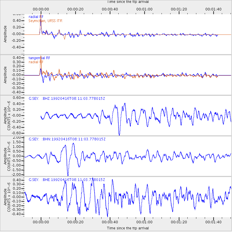
Signal To Noise
| Channel | StoN | STA | LTA |
| G:SEY: :BHN:19920416T08:11:03.778015Z | 4.5980363 | 3.2440335E-7 | 7.055258E-8 |
| G:SEY: :BHE:19920416T08:11:03.778015Z | 0.8998934 | 6.96508E-8 | 7.739895E-8 |
| G:SEY: :BHZ:19920416T08:11:03.778015Z | 1.8070908 | 1.0292928E-7 | 5.695856E-8 |
| Arrivals |
| Ps | 11 SECOND |
| PpPs | 29 SECOND |
| PsPs/PpSs | 39 SECOND |


