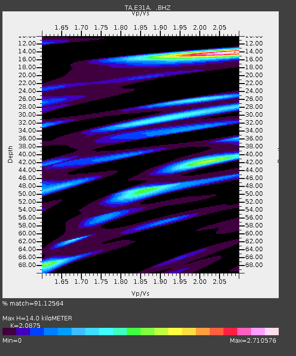
E31A Nome, ND, USA - Earthquake Result Viewer
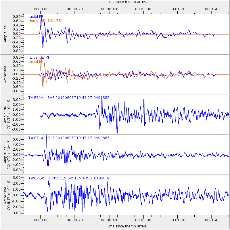
Earthquake location: Off East Coast Of Honshu, Japan
Earthquake latitude/longitude: 34.9/141.1
Earthquake time(UTC): 2012/06/05 (157) 19:31:33 GMT
Earthquake Depth: 15 km
Earthquake Magnitude: 6.2 MB, 6.0 MS, 6.1 MW, 6.1 MW
Earthquake Catalog/Contributor: WHDF/NEIC
Network: TA USArray Transportable Network (new EarthScope stations)
Station: E31A Nome, ND, USA
Lat/Lon: 46.56 N/97.89 W
Elevation: 427 m
Distance: 83.1 deg
Az: 36.582 deg
Baz: 314.803 deg
Ray Param: 0.04644798
Estimated Moho Depth: 14.0 km
Estimated Crust Vp/Vs: 2.09
Assumed Crust Vp: 6.498 km/s
Estimated Crust Vs: 3.113 km/s
Estimated Crust Poisson's Ratio: 0.35
Radial Match: 91.12564 %
Radial Bump: 400
Transverse Match: 76.25749 %
Transverse Bump: 400
SOD ConfigId: 458385
Insert Time: 2012-10-16 10:18:29.595 +0000
GWidth: 2.5
Max Bumps: 400
Tol: 0.001

Signal To Noise

ChannelStoNSTALTA
TA:E31A: :BHZ:20120605T19:43:27.049988Z12.4100262.3323853E-61.8794364E-7
TA:E31A: :BHN:20120605T19:43:27.049988Z3.239651.0482845E-63.2357954E-7
TA:E31A: :BHE:20120605T19:43:27.049988Z3.99151069.777078E-72.4494682E-7
Arrivals
Ps2.4 SECOND
PpPs6.5 SECOND
PsPs/PpSs8.9 SECOND