You are here: Home > Network List > TA - USArray Transportable Network (new EarthScope stations) Stations List
> Station C31A Landman Farms, Northwood, ND, USA > Earthquake Result Viewer
C31A Landman Farms, Northwood, ND, USA - Earthquake Result Viewer
| Earthquake location: |
Off East Coast Of Honshu, Japan |
| Earthquake latitude/longitude: |
34.9/141.1 |
| Earthquake time(UTC): |
2012/06/05 (157) 19:31:33 GMT |
| Earthquake Depth: |
15 km |
| Earthquake Magnitude: |
6.2 MB, 6.0 MS, 6.1 MW, 6.1 MW |
| Earthquake Catalog/Contributor: |
WHDF/NEIC |
|
| Network: |
TA USArray Transportable Network (new EarthScope stations) |
| Station: |
C31A Landman Farms, Northwood, ND, USA |
| Lat/Lon: |
47.79 N/97.73 W |
| Elevation: |
384 m |
|
| Distance: |
82.3 deg |
| Az: |
35.624 deg |
| Baz: |
314.794 deg |
| Ray Param: |
0.047000367 |
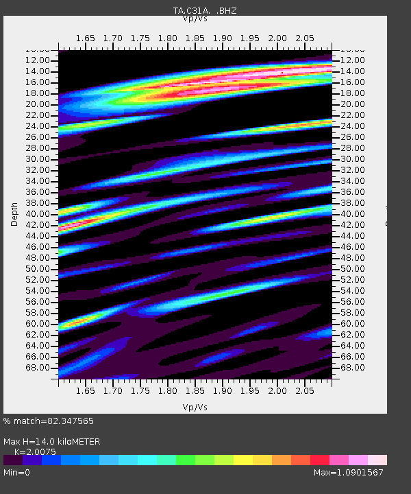
| Estimated Moho Depth: |
14.0 km |
| Estimated Crust Vp/Vs: |
2.01 |
| Assumed Crust Vp: |
6.498 km/s |
| Estimated Crust Vs: |
3.237 km/s |
| Estimated Crust Poisson's Ratio: |
0.33 |
|
| Radial Match: |
82.347565 % |
| Radial Bump: |
400 |
| Transverse Match: |
64.50068 % |
| Transverse Bump: |
400 |
| SOD ConfigId: |
458385 |
| Insert Time: |
2012-10-16 10:19:13.003 +0000 |
| GWidth: |
2.5 |
| Max Bumps: |
400 |
| Tol: |
0.001 |
|

Signal To Noise
| Channel | StoN | STA | LTA |
| TA:C31A: :BHZ:20120605T19:43:22.924988Z | 10.387269 | 1.6802287E-6 | 1.6175846E-7 |
| TA:C31A: :BHN:20120605T19:43:22.924988Z | 1.9481866 | 5.280366E-7 | 2.7104005E-7 |
| TA:C31A: :BHE:20120605T19:43:22.924988Z | 3.6343508 | 6.495522E-7 | 1.7872577E-7 |
| Arrivals |
| Ps | 2.2 SECOND |
| PpPs | 6.3 SECOND |
| PsPs/PpSs | 8.6 SECOND |


